IMAGES TAKEN NEAR TO
Peglars Way, SWINDON, SN1 7DA
Introduction
This page details the photographs taken nearby to Peglars Way, SN1 7DA by members of the Geograph project.
The Geograph project started in 2005 with the aim of publishing, organising and preserving representative images for every square kilometre of Great Britain, Ireland and the Isle of Man.

There are currently over 7.5m images from over14,400 individuals and you can help contribute to the project by visiting https://www.geograph.org.uk
Image Map
Images are licensed for reuse under creativecommons.org/licenses/by-sa/2.0
Notes
- Clicking on the map will re-center to the selected point.
- The higher the marker number, the further away the image location is from the centre of the postcode.
Image Listing (69 Images Found)
Images are licensed for reuse under creativecommons.org/licenses/by-sa/2.0
Image
Details
Distance
1
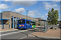
Bus at the Terminus
Swindon Buses' route 11 finishes here at Wychelstowe, as indeed so does the road for the time being.
This is a brand new suburb with large areas still to be developed. No doubt the bus route will get longer bit by bit as the builders move on.
Image: © Des Blenkinsopp
Taken: 17 Oct 2022
0.03 miles
2

New offices on Peglars Way, Wichelstowe
They have just been finished, here they are a year earlier https://www.geograph.org.uk/photo/5830926
Image: © David Howard
Taken: 26 Oct 2019
0.04 miles
3
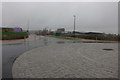
New roundabout on Peglars Way, Wichelstowe
Not yet visible on Google, Wichelstowe is gradually being built on a decade plus schedule, the building on the right is the new Waitrose while construction hasn't yet begun on the right. The position is approximate until the maps catch up.
Image: © David Howard
Taken: 26 Oct 2019
0.04 miles
4
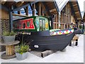
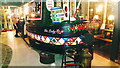
Narrowboat 'The Lady Rose', H&W, Wichelstowe, Swindon (bow)
The former canal boat has been re-purposed into a bijou dining area within the new H&W (Hall & Woodhouse) restaurant and bar complex. The stern can be seen here https://www.geograph.org.uk/photo/6092417
Image: © Brian Robert Marshall
Taken: 3 Jul 2019
0.04 miles
6
Narrowboat 'The Lady Rose', H&W, Wichelstowe, Swindon (stern)
The former canal boat has been re-purposed into a bijou dining area within the new H&W (Hall & Woodhouse) restaurant and bar complex. The bow can be seen here https://www.geograph.org.uk/photo/6200542
Image: © Brian Robert Marshall
Taken: 20 Mar 2019
0.05 miles
7
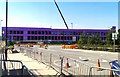
Construction- and road-works, Peglars Way, Swindon
Several things are happening at once in this location. Changes to the road layout to the left are taking place. Work on the Wilts and Berks canal is ongoing as is work on the large building in the background. The purple coloration is cladding.
Image: © Brian Robert Marshall
Taken: 5 Jul 2018
0.05 miles
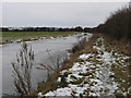
8
An Amazing Transformation
This is part of the brand new neighbourhood of Wichelstow on the (at the moment) southern edge of Swindon.
The old Wilts and Berks Canal, derelict for over 100 years, has been dug out, widened and turned into a large basin lined with new apartments, shops and a new waterside pub.
Unfortunately it is a long way from any other navigable waterway, so the effect is largely landscaping for the time being, although there is a trip boat moored up. It only has about 2 kms of restored canal to cruise along.
Image: © Des Blenkinsopp
Taken: 17 Oct 2022
0.06 miles
9
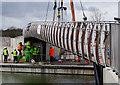
Wichelstowe bridge installation, Swindon (2)
The bridge seen here on the back of a truck Image has at last been installed. All that remains are some final checks before disconnecting the crane which hoisted the bridge into position.
Image: © Brian Robert Marshall
Taken: 18 Mar 2019
0.06 miles
10
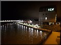
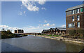
H&W bar/restaurant and the footbridge over the Wilts & Berks canal near Waitrose
Hall & Woodhouse's new canalside pub and restaurant photographed at about 5 am. The footbridge crosses to Waitrose, outside the photograph on the left.
Image: © Vieve Forward
Taken: 18 Mar 2020
0.06 miles