IMAGES TAKEN NEAR TO
Holne Road, SWINDON, SN1 7BQ
Introduction
This page details the photographs taken nearby to Holne Road, SN1 7BQ by members of the Geograph project.
The Geograph project started in 2005 with the aim of publishing, organising and preserving representative images for every square kilometre of Great Britain, Ireland and the Isle of Man.

There are currently over 7.5m images from over14,400 individuals and you can help contribute to the project by visiting https://www.geograph.org.uk
Image Map
Images are licensed for reuse under creativecommons.org/licenses/by-sa/2.0
Notes
- Clicking on the map will re-center to the selected point.
- The higher the marker number, the further away the image location is from the centre of the postcode.
Image Listing (75 Images Found)
Images are licensed for reuse under creativecommons.org/licenses/by-sa/2.0
Image
Details
Distance
1
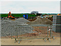
Building materials, East Wichel, Wichelstowe, Swindon
Builders' compounds are rarely glamorous but they are functional. Here, various aggregates and blocks share space with items of plant. The bridge in the background will one day carry a footpath over the M4. More on the Wichelstowe development here http://www.wichelstowe.co.uk/index.asp?pageid=1
Image: © Brian Robert Marshall
Taken: 20 May 2010
0.01 miles
2
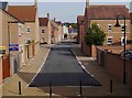
Rylane, East Wichel, Wichelstowe, Swindon
A modern residential development in East Wichel. The road crossing Rylane is Holne Road.
Image: © P L Chadwick
Taken: 24 Sep 2017
0.01 miles
3
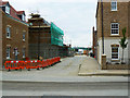
New housing under construction, East Wichel, Wichelstowe, Swindon
There is a diverse range of styles in this part of the large Wichelstowe development. These properties have a distinctly Georgian feel to them. More on Wichelstowe here courtesy of the developers http://www.wichelstowe.co.uk/index.asp?pageid=1
Image: © Brian Robert Marshall
Taken: 20 May 2010
0.02 miles
4
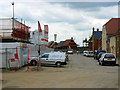
Barratt Homes site, East Wichel, Wichelstowe, Swindon
This a view west of the same road as is seen here http://www.geograph.org.uk/photo/1872836 There is a link in that one to the Wichelstowe website.
Image: © Brian Robert Marshall
Taken: 20 May 2010
0.03 miles
5
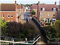
Footbridge over the Wilts & Berks Canal, East Wichel, Wichelstowe, Swindon
The footpath leads to Rylane, which is the road directly ahead. A view with this bridge in the distance can be seen here:- Image The houses in the foreground are adjacent to Mattocks Path.
Image: © P L Chadwick
Taken: 24 Sep 2017
0.03 miles
6
Progress at Wichelstowe, Swindon
I haven't been here for about a year. In that period development has taken place. New houses stand on what was once farmland. In the foreground a highly customised Ford Focus estate car can be seen. It is an '08' model.
Image: © Brian Robert Marshall
Taken: 20 May 2010
0.05 miles
7
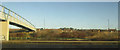
East Wichel from the M4
With a footbridge crossing the motorway carrying a bridleway from Wroughton.
Image: © Derek Harper
Taken: 19 Jan 2018
0.05 miles
8
East Wichel Way, Wichelstowe, Swindon
Although only about 150 homes are now occupied, a bus service is already in place. East Wichel is the first phase of the large Wichelstowe development. More here http://www.wichelstowe.co.uk/index.asp?pageid=1
Image: © Brian Robert Marshall
Taken: 20 May 2010
0.05 miles
9
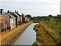
Wilts & Berks Canal adjacent to Mattocks Path & Yelland Walk, East Wichel, Wichelstowe, Swindon
At the time of writing the new route of the canal around Swindon doesn't extend to the east a great deal further than what can be seen in this photograph. It currently ends at Blackhorse Way (B4006). The group of houses on the left, nearest the camera, are adjacent to Mattocks Path, the others are adjacent to Yelland Walk. The canal footpath is a public footpath.
Image: © P L Chadwick
Taken: 24 Sep 2017
0.05 miles
10
Barratt showhome and sales office, East Wichel, Wichelstowe, Swindon
Barratts are one of several other builders in a consortium that also includes Bryant Homes, George Wimpey, Bloor Homes and Sovereign Housing. More on Wichelstowe here http://www.wichelstowe.co.uk/index.asp?pageid=1
Visible on the far horizon are hangars once used at the wartime RAF Wroughton airfield but now occupied by the Science Museum.
Image: © Brian Robert Marshall
Taken: 20 May 2010
0.05 miles