IMAGES TAKEN NEAR TO
Upper Minety, MALMESBURY, SN16 9YD
Introduction
This page details the photographs taken nearby to SN16 9YD by members of the Geograph project.
The Geograph project started in 2005 with the aim of publishing, organising and preserving representative images for every square kilometre of Great Britain, Ireland and the Isle of Man.

There are currently over 7.5m images from over14,400 individuals and you can help contribute to the project by visiting https://www.geograph.org.uk
Image Map
Images are licensed for reuse under creativecommons.org/licenses/by-sa/2.0
Notes
- Clicking on the map will re-center to the selected point.
- The higher the marker number, the further away the image location is from the centre of the postcode.
Image Listing (14 Images Found)
Images are licensed for reuse under creativecommons.org/licenses/by-sa/2.0
Image
Details
Distance
1
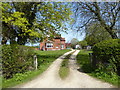
The barn
A modern house, located near Cooles farm.
Image: © Roger Cornfoot
Taken: 29 Jan 2007
0.03 miles
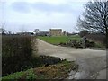
2
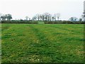
Field, north of The Barn, Upper Minety
The barn appears to be the large residence to the left of the farm buildings.
Image: © Brian Robert Marshall
Taken: 29 Mar 2011
0.15 miles
3
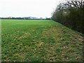
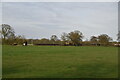
Field near Cooles Farm, Upper Minety
The farm can be seen in the background across this flat pastoral field.
Image: © Brian Robert Marshall
Taken: 29 Mar 2011
0.18 miles
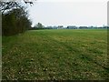
5
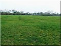
Ridge and furrow cultivation relics, near Minety Crossing, Upper Minety
The distinctive landforms have been left behind by generations of farmers or smallholders who worked in the days before tractors. At some point after the last of them ceased ploughing the land it was given over to grass and never subsequently ploughed. More on wiki http://en.wikipedia.org/wiki/Ridge_and_furrow
Image: © Brian Robert Marshall
Taken: 29 Mar 2011
0.19 miles
6
Ridges and furrows near Minety Crossing, Upper Minety
Ridge and furrow landforms arise from ancient methods of ploughing the soil. Often, these old reminders of pre-mechanised cultivation methods are obliterated by modern techniques, but where the land has been turned over to grass, the ridges and furrows remain. More on wikipedia http://en.wikipedia.org/wiki/Ridge_and_furrow The small hamlet named either Minety Crossing (Network Rail) or simply The Crossing (Royal Mail) can be seen in the background.
Image: © Brian Robert Marshall
Taken: 29 Mar 2011
0.20 miles
7
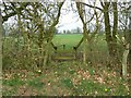
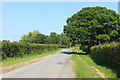
Stile and bridge over a ditch, near Upper Minety
This is the opposing view to this one Image
Image: © Brian Robert Marshall
Taken: 29 Mar 2011
0.21 miles
8
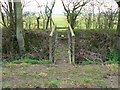
Bridge and stile over a ditch, near Upper Minety
The bridge carries a footpath over a field-side ditch that runs north to south. The ditch only appears on the 1:25K map.
Image: © Brian Robert Marshall
Taken: 29 Mar 2011
0.21 miles