IMAGES TAKEN NEAR TO
Wortheys Close, MALMESBURY, SN16 9UD
Introduction
This page details the photographs taken nearby to Wortheys Close, SN16 9UD by members of the Geograph project.
The Geograph project started in 2005 with the aim of publishing, organising and preserving representative images for every square kilometre of Great Britain, Ireland and the Isle of Man.

There are currently over 7.5m images from over14,400 individuals and you can help contribute to the project by visiting https://www.geograph.org.uk
Image Map
Images are licensed for reuse under creativecommons.org/licenses/by-sa/2.0
Notes
- Clicking on the map will re-center to the selected point.
- The higher the marker number, the further away the image location is from the centre of the postcode.
Image Listing (16 Images Found)
Images are licensed for reuse under creativecommons.org/licenses/by-sa/2.0
Image
Details
Distance
1
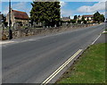
Road past Malmesbury Cemetery
Looking along Tetbury Hill past the eastern edge of the cemetery.
Image: © Jaggery
Taken: 17 Aug 2014
0.22 miles
2
Queen Elizabeth II postbox, Tetbury Hill, Malmesbury
A newer-style postbox on the west side of Tetbury Hill.
Image: © Jaggery
Taken: 17 Aug 2014
0.22 miles
3
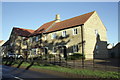
New housing on Tetbury Hill
This site was until recently occupied by The Suffolk Arms, a pub with an Ordnance Survey benchmark levelled at 91.8m above Ordnance Datum Newlyn. The houses in the picture are Nos 16 and 17.
Image: © Roger Templeman
Taken: 17 Dec 2011
0.22 miles
4
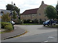
Reeds Farm Road, Malmesbury
The road heads NE away from the roundabout at the junction of Tetbury Hill and Gloucester Road.
Image: © Jaggery
Taken: 17 Aug 2014
0.23 miles
5
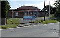
Drill Hall, Tetbury Hill, Malmesbury
Home of the Royal Air Force Air Cadets 992 (Malmesbury) Squadron.
Image: © Jaggery
Taken: 17 Aug 2014
0.23 miles
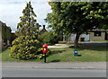
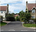
6
Minot Close, Malmesbury
Viewed across Tetbury Hill.
Image: © Jaggery
Taken: 17 Aug 2014
0.24 miles
7
Drill Hall, Tetbury Hill
Home of the Air Training Corps (ATC) 992 Malmesbury Squadron.
Image: © Vieve Forward
Taken: 28 Jun 2016
0.24 miles
8
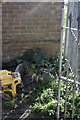
Benchmark on the Air Cadet Centre, Tetbury Hill
Ordnance Survey cut mark benchmark described on the Bench Mark Database at http://www.bench-marks.org.uk/bm40574
Image: © Roger Templeman
Taken: 17 Dec 2011
0.24 miles
9
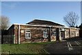
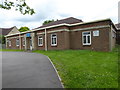
Air Cadet Centre, Tetbury Hill
MOD Air Training Corps Malmesbury 992 Squadron building, which has an OS benchmark Image on its left face.
Image: © Roger Templeman
Taken: 17 Dec 2011
0.24 miles
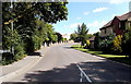
10
William Stumpes Close, Malmesbury
Cul-de-sac on the west side of Tetbury Hill.
Image: © Jaggery
Taken: 17 Aug 2014
0.24 miles