IMAGES TAKEN NEAR TO
Oxleaze Lane, MALMESBURY, SN16 9TS
Introduction
This page details the photographs taken nearby to Oxleaze Lane, SN16 9TS by members of the Geograph project.
The Geograph project started in 2005 with the aim of publishing, organising and preserving representative images for every square kilometre of Great Britain, Ireland and the Isle of Man.

There are currently over 7.5m images from over14,400 individuals and you can help contribute to the project by visiting https://www.geograph.org.uk
Image Map
Images are licensed for reuse under creativecommons.org/licenses/by-sa/2.0
Notes
- Clicking on the map will re-center to the selected point.
- The higher the marker number, the further away the image location is from the centre of the postcode.
Image Listing (28 Images Found)
Images are licensed for reuse under creativecommons.org/licenses/by-sa/2.0
Image
Details
Distance
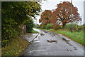
1
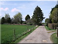
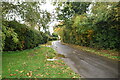
Lane to Peartree Cottage, Hankerton
This lane leads to Peartree Cottage. On the right is the turn-off for Cherrytree Cottage.
Image: © Vieve Forward
Taken: 6 Apr 2012
0.02 miles
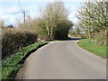
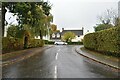
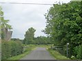
4
Lane at Hankerton
Looking south along the lane, which bypasses the main concentration of village dwellings on Follyfield off to the left just ahead.
Image: © Trevor Rickard
Taken: 13 Jul 2011
0.08 miles
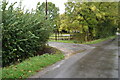
6
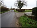
Old milk churn stand
Until dairy farms installed bulk tanks to store milk which is collected by a bulk tanker lorry, milk was transported in churns, and placed on milk churn stands such as this one on the roadside in Hankerton.
Image: © Philip Halling
Taken: 4 Dec 2018
0.10 miles
7
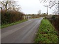
Hankerton Bridge
Hankerton Bridge crossing a stream near the village of Hankerton.
Image: © Philip Halling
Taken: 4 Dec 2018
0.10 miles
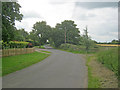
10
Lane north of Hankerton
Heading north out of the village with the entrance to a network of public footpaths on the right.
Image: © Trevor Rickard
Taken: 13 Jul 2011
0.11 miles