IMAGES TAKEN NEAR TO
Oaksey, MALMESBURY, SN16 9TF
Introduction
This page details the photographs taken nearby to SN16 9TF by members of the Geograph project.
The Geograph project started in 2005 with the aim of publishing, organising and preserving representative images for every square kilometre of Great Britain, Ireland and the Isle of Man.

There are currently over 7.5m images from over14,400 individuals and you can help contribute to the project by visiting https://www.geograph.org.uk
Image Map
Images are licensed for reuse under creativecommons.org/licenses/by-sa/2.0
Notes
- Clicking on the map will re-center to the selected point.
- The higher the marker number, the further away the image location is from the centre of the postcode.
Image Listing (81 Images Found)
Images are licensed for reuse under creativecommons.org/licenses/by-sa/2.0
Image
Details
Distance
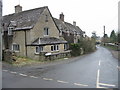
1
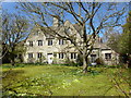
Cotswold house, Oaksey
A typical Cotswold stone house with high gables and stone tiled roof.
Image: © Vieve Forward
Taken: 20 Apr 2016
0.03 miles
4
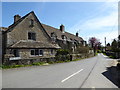
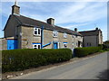
Cottages, Minety Lane, Oaksey
Typical Cotswold stone cottages.
Image: © Vieve Forward
Taken: 20 Apr 2016
0.12 miles
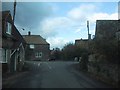
6
Junction of Minety Lane with The Street, Oaksey
Image: © Nick Smith
Taken: 4 Jan 2009
0.12 miles
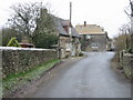
7
Cottages, Minety Lane, Oaksey
Cotswold stone cottages.
Image: © Vieve Forward
Taken: 20 Apr 2016
0.15 miles