IMAGES TAKEN NEAR TO
Brokenborough, MALMESBURY, SN16 9SR
Introduction
This page details the photographs taken nearby to SN16 9SR by members of the Geograph project.
The Geograph project started in 2005 with the aim of publishing, organising and preserving representative images for every square kilometre of Great Britain, Ireland and the Isle of Man.

There are currently over 7.5m images from over14,400 individuals and you can help contribute to the project by visiting https://www.geograph.org.uk
Image Map
Images are licensed for reuse under creativecommons.org/licenses/by-sa/2.0
Notes
- Clicking on the map will re-center to the selected point.
- The higher the marker number, the further away the image location is from the centre of the postcode.
Image Listing (5 Images Found)
Images are licensed for reuse under creativecommons.org/licenses/by-sa/2.0
Image
Details
Distance
1
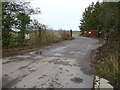
Entrance to the Old Airfield
Entrance to the Old Airfield of Long Newnton, today there is a solar farm on this former airfield.
Image: © Philip Halling
Taken: 4 Dec 2018
0.15 miles
3
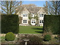
Ashlands Court
As a previous Geograph-er has noted, there is only one spot from which a view of this fine house can be taken.
Image: © David Purchase
Taken: 10 Mar 2012
0.22 miles
4
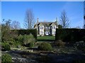
Ashlands Court
Well screened from the road, except for this gap in the hedge.
Image: © Roger Cornfoot
Taken: 25 Jan 2007
0.22 miles
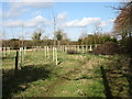
5
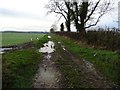
Farm headland track
Farm headland track near Ashlands Court, near Brokenborough.
Image: © Philip Halling
Taken: 4 Dec 2018
0.25 miles