
IMAGES TAKEN NEAR TO
Kemble Road, MALMESBURY, SN16 9SQ
Introduction
This page details the photographs taken nearby to Kemble Road, SN16 9SQ by members of the Geograph project.
The Geograph project started in 2005 with the aim of publishing, organising and preserving representative images for every square kilometre of Great Britain, Ireland and the Isle of Man.

There are currently over 7.5m images from over14,400 individuals and you can help contribute to the project by visiting https://www.geograph.org.uk
Image Map
Images are licensed for reuse under creativecommons.org/licenses/by-sa/2.0
Notes
- Clicking on the map will re-center to the selected point.
- The higher the marker number, the further away the image location is from the centre of the postcode.
Image Listing (10 Images Found)
Images are licensed for reuse under creativecommons.org/licenses/by-sa/2.0
Image
Details
Distance
1
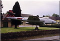
Gate guard at RAF Kemble, 1986
This aircraft was a Gloster Meteor F.Mk.8 (WH364) and was preserved as a gate-guard outside the main entrance to RAF Station Kemble. Does anyone know where it is now?
Image: © Stephen Williams
Taken: 26 May 1986
0.09 miles
2
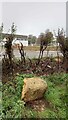
Old Milestone, Kemble Airport A429
Erected byMalmesbury First Turnpike Trust, A429, in the parish of Crudwell (North Wiltshire District), Kemble Road, East side of road, opposite entrance to Kemble Enterprise Park. Originally bore an OS Benchmark representing 125.9 m ASL.
Inscription (was): CIRENCESTER / 5 / MALMESBURY / 6
Grade II listed. Nᴼ. 1022237 https://historicengland.org.uk/listing/the-list/list-entry/1022237
Milestone Society National ID: WI_MYCI06
Image: © Tom Blanden
Taken: 14 Nov 2022
0.12 miles
3
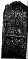
Old Milestone by the A429, Kemble Road, Crudwell parish
Malmesbury First plate by the A429, in parish of Crudwell (North Wiltshire District), Kemble Road, East side of road, opposite entrance to Kemble Enterprise Park.
Lost since 2000
Inscription reads:-
CIRENCESTER
5
MALMESBURY
6
Grade II listed.
List Entry Number: 1022237 https://historicengland.org.uk/listing/the-list/list-entry/1022237
Milestone Society National ID: WI_MYCI06
Image: © Milestone Society
Taken: Unknown
0.13 miles
4

Crudwell - Water Tower
There are many relics of the former RAF Kemble which is now home to Cotswold Business Park and to Cotswold Airport.
Image: © Colin Smith
Taken: 8 Jun 2025
0.16 miles
5
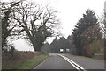
A429 just north of entrance to Kemble airfield
Image: © John Firth
Taken: 11 Apr 2013
0.16 miles
6

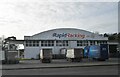
Kemble - Cotswold Business Park
Industrial estate centred around the former RAF Kemble airfield [now Cotswold Airport]. Many of the remaining former hangars now contain small businesses e.g. Rapid Racking for industrial shelving.
www.rapidracking.com
Image: © Colin Smith
Taken: 8 Jun 2025
0.18 miles
7

Kemble - Cotswold Business Park
Industrial estate centred around the former RAF Kemble airfield [now Cotswold Airport]. Many of the remaining former hangars now contain small businesses e.g. Rapid Racking for industrial shelving.
www.rapidracking.com
Image: © Colin Smith
Taken: 8 Jun 2025
0.22 miles
10
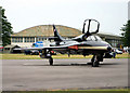
Kemble Airfield and Resident
A resident of Kemble in front of one of the large hangars on the airfield. The famous 'Red Arrows' were once based here.
Image: © Richard Thomas
Taken: 18 Jun 2006
0.24 miles