IMAGES TAKEN NEAR TO
Sambourne Road, MALMESBURY, SN16 9RQ
Introduction
This page details the photographs taken nearby to Sambourne Road, SN16 9RQ by members of the Geograph project.
The Geograph project started in 2005 with the aim of publishing, organising and preserving representative images for every square kilometre of Great Britain, Ireland and the Isle of Man.

There are currently over 7.5m images from over14,400 individuals and you can help contribute to the project by visiting https://www.geograph.org.uk
Image Map
Images are licensed for reuse under creativecommons.org/licenses/by-sa/2.0
Notes
- Clicking on the map will re-center to the selected point.
- The higher the marker number, the further away the image location is from the centre of the postcode.
Image Listing (2 Images Found)
Images are licensed for reuse under creativecommons.org/licenses/by-sa/2.0
Image
Details
Distance
1
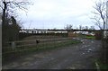
Gypsy site at Minety
This land was purchased and occupied in 2004.
Image: © Roger Cornfoot
Taken: 17 Jan 2007
0.05 miles
2
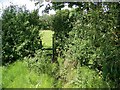
Footpath near Minety
The stile gives access to the footpath that takes walkers from Swiss Cottage to Minety.
Image: © Maigheach-gheal
Taken: 9 Aug 2009
0.06 miles