IMAGES TAKEN NEAR TO
Queen Street, MALMESBURY, SN16 9RL
Introduction
This page details the photographs taken nearby to Queen Street, SN16 9RL by members of the Geograph project.
The Geograph project started in 2005 with the aim of publishing, organising and preserving representative images for every square kilometre of Great Britain, Ireland and the Isle of Man.

There are currently over 7.5m images from over14,400 individuals and you can help contribute to the project by visiting https://www.geograph.org.uk
Image Map
Images are licensed for reuse under creativecommons.org/licenses/by-sa/2.0
Notes
- Clicking on the map will re-center to the selected point.
- The higher the marker number, the further away the image location is from the centre of the postcode.
Image Listing (4 Images Found)
Images are licensed for reuse under creativecommons.org/licenses/by-sa/2.0
Image
Details
Distance
1
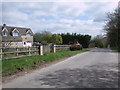
Queen Street, Braydon
House beside Queen Street, Braydon. The armoured vehicle parked outside is a reminder that the Holland Handling recycling firm is nearby, see also Image
Image: © Vieve Forward
Taken: 18 Apr 2014
0.13 miles
2
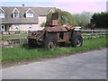
Armoured vehicle, Queen Street, Braydon
Armoured vehicle parked on the roadside verge in Queen Street, Braydon, see also Image The recycling firm Holland Handling is nearby.
Image: © Vieve Forward
Taken: 18 Apr 2014
0.13 miles
3
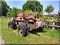
Classic military vehicle, Queen Street, Braydon
The old armoured car has been here quite some time. It looks no less pristine now than it did six years ago Image
Image: © Brian Robert Marshall
Taken: 23 Jun 2020
0.17 miles
4
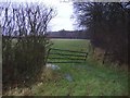
Farmland next to Ravensroost wood.
Ravensroost wood is maintained by Wiltshire Wildlife.
Image: © Roger Cornfoot
Taken: 31 Dec 2006
0.24 miles