IMAGES TAKEN NEAR TO
Hornbury Hill, MALMESBURY, SN16 9QH
Introduction
This page details the photographs taken nearby to Hornbury Hill, SN16 9QH by members of the Geograph project.
The Geograph project started in 2005 with the aim of publishing, organising and preserving representative images for every square kilometre of Great Britain, Ireland and the Isle of Man.

There are currently over 7.5m images from over14,400 individuals and you can help contribute to the project by visiting https://www.geograph.org.uk
Image Map
Images are licensed for reuse under creativecommons.org/licenses/by-sa/2.0
Notes
- Clicking on the map will re-center to the selected point.
- The higher the marker number, the further away the image location is from the centre of the postcode.
Image Listing (37 Images Found)
Images are licensed for reuse under creativecommons.org/licenses/by-sa/2.0
Image
Details
Distance
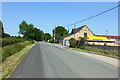
3
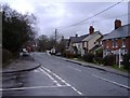
The centre of Minety
Taken between downpours!
Image: © Roger Cornfoot
Taken: 31 Dec 2006
0.11 miles
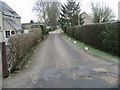
4
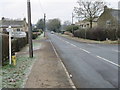
Hornbury Hill
Residential road in Minety.
Image: © Wayland Smith
Taken: 30 May 2020
0.12 miles
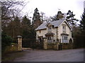
5
Hornbury Hill
Entrance of Kinch Coaches.
Image: © Wayland Smith
Taken: 30 May 2020
0.13 miles
6
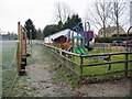
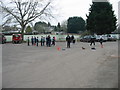
Children's play area at Minety playing field
Image: © Nick Smith
Taken: 4 Jan 2009
0.13 miles
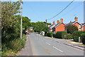
8
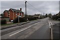
Hornbury Hill, Minety
Minor road passing through the village of Minety.
Image: © Philip Halling
Taken: 17 Mar 2018
0.13 miles
10
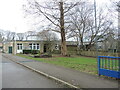
Minety C. of E. primary school
A surprisingly large school and pre-school for such a quiet village.
Image: © Neil Owen
Taken: 30 Dec 2024
0.15 miles