IMAGES TAKEN NEAR TO
Dog Trap Lane, MALMESBURY, SN16 9PW
Introduction
This page details the photographs taken nearby to Dog Trap Lane, SN16 9PW by members of the Geograph project.
The Geograph project started in 2005 with the aim of publishing, organising and preserving representative images for every square kilometre of Great Britain, Ireland and the Isle of Man.

There are currently over 7.5m images from over14,400 individuals and you can help contribute to the project by visiting https://www.geograph.org.uk
Image Map
Images are licensed for reuse under creativecommons.org/licenses/by-sa/2.0
Notes
- Clicking on the map will re-center to the selected point.
- The higher the marker number, the further away the image location is from the centre of the postcode.
Image Listing (5 Images Found)
Images are licensed for reuse under creativecommons.org/licenses/by-sa/2.0
Image
Details
Distance
1
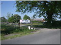
Woodward Farm caravan site, Dog Trap Lane
This is a Caravan Club certified location, for 5 members only.
Image: © Vieve Forward
Taken: 17 May 2014
0.19 miles
2
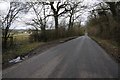
Road to Upper Minety
Road to Upper Minety from Minety.
Image: © Philip Halling
Taken: 17 Mar 2018
0.20 miles
3
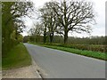
The road past Minety Park towards Minety
The entrance to Minety Park provides a convenient pull-in to grab a quick snap of a well-maintained minor road in north Wiltshire.
Image: © Brian Robert Marshall
Taken: 4 Apr 2011
0.21 miles
4
Bridleway at Minety
Bridleway passing through a wood at Minety.
Image: © Philip Halling
Taken: 17 Mar 2018
0.24 miles
5
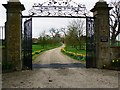
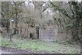
Gateway to Minety Park, Minety
The gateway has been moved since the last time it was photographed.
Image: © Brian Robert Marshall
Taken: 4 Apr 2011
0.24 miles