IMAGES TAKEN NEAR TO
Manor View, MALMESBURY, SN16 9PD
Introduction
This page details the photographs taken nearby to Manor View, SN16 9PD by members of the Geograph project.
The Geograph project started in 2005 with the aim of publishing, organising and preserving representative images for every square kilometre of Great Britain, Ireland and the Isle of Man.

There are currently over 7.5m images from over14,400 individuals and you can help contribute to the project by visiting https://www.geograph.org.uk
Image Map
Images are licensed for reuse under creativecommons.org/licenses/by-sa/2.0
Notes
- Clicking on the map will re-center to the selected point.
- The higher the marker number, the further away the image location is from the centre of the postcode.
Image Listing (17 Images Found)
Images are licensed for reuse under creativecommons.org/licenses/by-sa/2.0
Image
Details
Distance
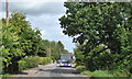
1
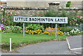
Little Badminton Lane Sign, Lea, Wiltshire 2019
Image: © Ray Bird
Taken: 29 Aug 2019
0.07 miles
3
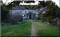
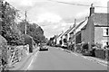
Street Farm, The Street, Lea
Records of Street Farm go back to the late-18th century. http://www.british-history.ac.uk/report.aspx?compid=116148
Image: © Vieve Forward
Taken: 29 Feb 2012
0.10 miles
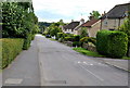
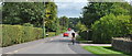
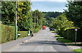
7
Bus Service, The Street, Lea, Wiltshire 2019
Image: © Ray Bird
Taken: 29 Aug 2019
0.16 miles
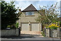
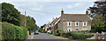
10
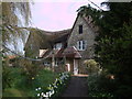
St. Leonard's Cottage, School Lane, Lea
A beautiful thatched cottage hidden away at the end of School Lane, Lea.
Image: © Vieve Forward
Taken: 20 Apr 2012
0.19 miles