IMAGES TAKEN NEAR TO
Garsdon, MALMESBURY, SN16 9NW
Introduction
This page details the photographs taken nearby to SN16 9NW by members of the Geograph project.
The Geograph project started in 2005 with the aim of publishing, organising and preserving representative images for every square kilometre of Great Britain, Ireland and the Isle of Man.

There are currently over 7.5m images from over14,400 individuals and you can help contribute to the project by visiting https://www.geograph.org.uk
Image Map
Images are licensed for reuse under creativecommons.org/licenses/by-sa/2.0
Notes
- Clicking on the map will re-center to the selected point.
- The higher the marker number, the further away the image location is from the centre of the postcode.
Image Listing (5 Images Found)
Images are licensed for reuse under creativecommons.org/licenses/by-sa/2.0
Image
Details
Distance
1
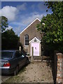
The Old Chapel, Garsdon
Hidden away down a tiny lane is this old non-conformist chapel, now converted to a dwelling.
Image: © Vieve Forward
Taken: 19 Oct 2013
0.12 miles
2
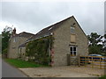
Former chapel, between Garsdon and Charlton
Image: © Basher Eyre
Taken: 28 Jun 2015
0.12 miles
3
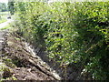
Ditching near Garsdon
The ditch has been recently been cleared.
Image: © Maigheach-gheal
Taken: 27 Aug 2010
0.18 miles
4
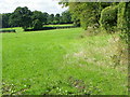
Footpath near Garsdon
The footpath initially follows the hedge as it takes walkers towards Charlton.
Image: © Maigheach-gheal
Taken: 27 Aug 2010
0.21 miles
5
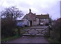
Farm on Charlton heath
Farmhouse, complete with a proverbial five bar gate.
Image: © Roger Cornfoot
Taken: 31 Dec 2006
0.23 miles