IMAGES TAKEN NEAR TO
Swindon Road, MALMESBURY, SN16 9ND
Introduction
This page details the photographs taken nearby to Swindon Road, SN16 9ND by members of the Geograph project.
The Geograph project started in 2005 with the aim of publishing, organising and preserving representative images for every square kilometre of Great Britain, Ireland and the Isle of Man.

There are currently over 7.5m images from over14,400 individuals and you can help contribute to the project by visiting https://www.geograph.org.uk
Image Map
Images are licensed for reuse under creativecommons.org/licenses/by-sa/2.0
Notes
- Clicking on the map will re-center to the selected point.
- The higher the marker number, the further away the image location is from the centre of the postcode.
Image Listing (7 Images Found)
Images are licensed for reuse under creativecommons.org/licenses/by-sa/2.0
Image
Details
Distance
3
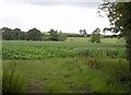
Maize by the Avon
There are scattered trees across the field. Seen from a gateway below the B4042.
Image: © Derek Harper
Taken: 19 Jul 2011
0.23 miles
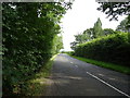
4
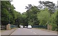
B4042 near Lea Crescent
Taken from the same spot as Image, looking along the B road towards Malmesbury.
Image: © Derek Harper
Taken: 19 Jul 2011
0.23 miles
6
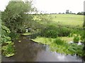
River Avon from Cow Bridge
Similar to Image, looking more downstream, with a willow spreading across the placid river.
Image: © Derek Harper
Taken: 19 Jul 2011
0.25 miles
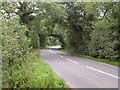
7
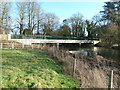
Cow Bridge near Malmesbury
This is a very new replacement of a 1928 reinforced concrete bridge built according to the Mouchel-Hennebique method. This was reported as in a poor state and due for replacement in 2008
Image: © Chris Allen
Taken: 8 Jan 2012
0.25 miles