IMAGES TAKEN NEAR TO
Eastcourt, MALMESBURY, SN16 9HR
Introduction
This page details the photographs taken nearby to SN16 9HR by members of the Geograph project.
The Geograph project started in 2005 with the aim of publishing, organising and preserving representative images for every square kilometre of Great Britain, Ireland and the Isle of Man.

There are currently over 7.5m images from over14,400 individuals and you can help contribute to the project by visiting https://www.geograph.org.uk
Image Map
Images are licensed for reuse under creativecommons.org/licenses/by-sa/2.0
Notes
- Clicking on the map will re-center to the selected point.
- The higher the marker number, the further away the image location is from the centre of the postcode.
Image Listing (4 Images Found)
Images are licensed for reuse under creativecommons.org/licenses/by-sa/2.0
Image
Details
Distance
1
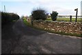
Entrance and road to Hill Farm
Entrance and road to Hill Farm near Eastcourt, this is also the route of a footpath to Chelworth.
Image: © Philip Halling
Taken: 16 Jan 2016
0.07 miles
2
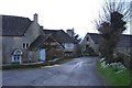
Hill farm, Eastcourt
Situated to the south of Oaksey Wood.
Image: © Roger Cornfoot
Taken: 12 Feb 2007
0.13 miles
3
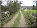
Flintham House
A gravel track leads south, from the Eastcourt to Oaksey road.
Image: © Roger Cornfoot
Taken: 12 Feb 2007
0.14 miles
4
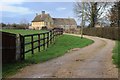
Oatridge Farm
Entrance and drive to Oatridge Farm in the village of Eastcourt.
Image: © Philip Halling
Taken: 16 Jan 2016
0.19 miles