IMAGES TAKEN NEAR TO
Crudwell, MALMESBURY, SN16 9EU
Introduction
This page details the photographs taken nearby to SN16 9EU by members of the Geograph project.
The Geograph project started in 2005 with the aim of publishing, organising and preserving representative images for every square kilometre of Great Britain, Ireland and the Isle of Man.

There are currently over 7.5m images from over14,400 individuals and you can help contribute to the project by visiting https://www.geograph.org.uk
Image Map
Images are licensed for reuse under creativecommons.org/licenses/by-sa/2.0
Notes
- Clicking on the map will re-center to the selected point.
- The higher the marker number, the further away the image location is from the centre of the postcode.
Image Listing (13 Images Found)
Images are licensed for reuse under creativecommons.org/licenses/by-sa/2.0
Image
Details
Distance
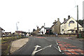
3
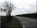
The A429 just south of Crudwell
The main road is heading for Malmesbury.
Image: © David Purchase
Taken: 10 Mar 2012
0.10 miles
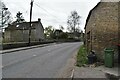
5
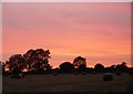
Crudwell
Evening sky taken from Gossey Corner looking west towards Long Newnton airfield
Image: © Paul Best
Taken: 12 Jun 2006
0.14 miles
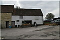
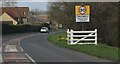
7
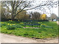
A quiet corner
This bench amongst the daffodils must be a boon for cyclists and walkers travelling these lanes.
Image: © David Collins
Taken: 27 Mar 2007
0.15 miles