IMAGES TAKEN NEAR TO
Crudwell, MALMESBURY, SN16 9EF
Introduction
This page details the photographs taken nearby to SN16 9EF by members of the Geograph project.
The Geograph project started in 2005 with the aim of publishing, organising and preserving representative images for every square kilometre of Great Britain, Ireland and the Isle of Man.

There are currently over 7.5m images from over14,400 individuals and you can help contribute to the project by visiting https://www.geograph.org.uk
Image Map
Images are licensed for reuse under creativecommons.org/licenses/by-sa/2.0
Notes
- Clicking on the map will re-center to the selected point.
- The higher the marker number, the further away the image location is from the centre of the postcode.
Image Listing (6 Images Found)
Images are licensed for reuse under creativecommons.org/licenses/by-sa/2.0
Image
Details
Distance
1
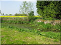
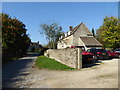
Stone Stile, West Crudwell
On Wiltshire footpath CRUD8 looking East to the access road for the Holiday Cottages.
The view West is Image
Image: © Jayne Tovey
Taken: 5 Sep 2023
0.07 miles
2
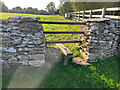
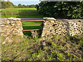
Stone Stile, West Crudwell
On Wiltshire footpath CRUD8 looking East from the access road for the Holiday Cottages.
The view East is Image
Image: © Jayne Tovey
Taken: 5 Sep 2023
0.07 miles
5
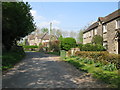
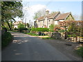
Village houses, Chedglow
Cotswold stone houses in Chedglow, a classic American pick-up truck on the drive of the nearest.
Image: © Vieve Forward
Taken: 10 Oct 2018
0.24 miles