IMAGES TAKEN NEAR TO
Bullocks Horn, MALMESBURY, SN16 9DZ
Introduction
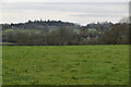
This page details the photographs taken nearby to Bullocks Horn, SN16 9DZ by members of the Geograph project.
The Geograph project started in 2005 with the aim of publishing, organising and preserving representative images for every square kilometre of Great Britain, Ireland and the Isle of Man.

There are currently over 7.5m images from over14,400 individuals and you can help contribute to the project by visiting https://www.geograph.org.uk
Image Map
Images are licensed for reuse under creativecommons.org/licenses/by-sa/2.0
Notes
- Clicking on the map will re-center to the selected point.
- The higher the marker number, the further away the image location is from the centre of the postcode.
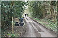
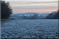
Image Listing (33 Images Found)
Images are licensed for reuse under creativecommons.org/licenses/by-sa/2.0
Image
Details
Distance
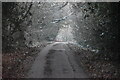
1
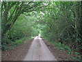
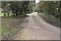
Bullock's Horn Lane
No-through-road heading south from the little settlement of only four houses and meandering between overgrown hedges to the B4040 three-quarters of a mile ahead. This really is the back of beyond and a name to match.
Image: © Trevor Rickard
Taken: 13 Jul 2011
0.04 miles
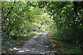
2
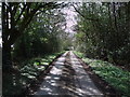
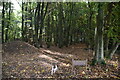
Lane near Bullock's Horn
This narrow lane connects the small collection of houses at the oddly-named Bullock's Horn with the main road from Malmesbury to Cricklade.
Image: © Vieve Forward
Taken: 6 Apr 2012
0.06 miles