IMAGES TAKEN NEAR TO
Pink Lane, MALMESBURY, SN16 9DS
Introduction
This page details the photographs taken nearby to Pink Lane, SN16 9DS by members of the Geograph project.
The Geograph project started in 2005 with the aim of publishing, organising and preserving representative images for every square kilometre of Great Britain, Ireland and the Isle of Man.

There are currently over 7.5m images from over14,400 individuals and you can help contribute to the project by visiting https://www.geograph.org.uk
Image Map
Images are licensed for reuse under creativecommons.org/licenses/by-sa/2.0
Notes
- Clicking on the map will re-center to the selected point.
- The higher the marker number, the further away the image location is from the centre of the postcode.
Image Listing (5 Images Found)
Images are licensed for reuse under creativecommons.org/licenses/by-sa/2.0
Image
Details
Distance
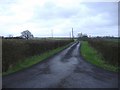
2
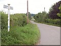
Pink Lane
From the junction at Great and Little Elm Farms, with a signpost on the left.
Image: © Derek Harper
Taken: 19 Jul 2011
0.12 miles
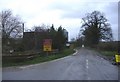
3
Near Hill Farm
Isolated houses near Hill Farm.
Image: © Wayland Smith
Taken: 25 Apr 2020
0.15 miles
4
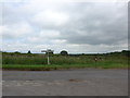
Long-term road closure
This minor road near Braydon has been closed for over five years. The road runs along the top of a lake embankment, which had deteriorated badly. Vital work is being undertaken to strengthen the embankment which holds back Braydon Pond.
Image: © Roger Cornfoot
Taken: 31 Dec 2006
0.25 miles
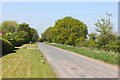
5
The road to Turk's farm
A recently metalled farm road.
Image: © Roger Cornfoot
Taken: 31 Dec 2006
0.25 miles