IMAGES TAKEN NEAR TO
Back Hill, MALMESBURY, SN16 9BT
Introduction
This page details the photographs taken nearby to Back Hill, SN16 9BT by members of the Geograph project.
The Geograph project started in 2005 with the aim of publishing, organising and preserving representative images for every square kilometre of Great Britain, Ireland and the Isle of Man.

There are currently over 7.5m images from over14,400 individuals and you can help contribute to the project by visiting https://www.geograph.org.uk
Image Map
Images are licensed for reuse under creativecommons.org/licenses/by-sa/2.0
Notes
- Clicking on the map will re-center to the selected point.
- The higher the marker number, the further away the image location is from the centre of the postcode.
Image Listing (578 Images Found)
Images are licensed for reuse under creativecommons.org/licenses/by-sa/2.0
Image
Details
Distance
4
Malmesbury pumping station
Located right by the bridge, evidently containing a lot of heavy machinery and some powerful electrical installations.
Image: © Neil Owen
Taken: 1 Jul 2014
0.02 miles
5
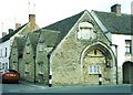
Malmesbury: St. John?s almshouses
The arch in the right-hand end as we look is reckoned to date to about 1185 and is probably a reminder of a former chapel and hospital on this site. Much more in-depth discussion will be found here: http://www.davidforward.co.uk/almshouse/almshouse.php
Image: © Chris Downer
Taken: 16 Feb 2002
0.02 miles
6
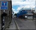
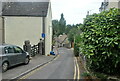
Unsuitable for HGVs, Malmesbury
Wider for its 50 metre course from High Street behind the camera, St John's Street is narrow ahead.
Image: © Jaggery
Taken: 17 Aug 2014
0.03 miles
7
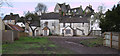
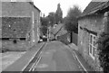
Roundmead, St. John Street, Malmesbury
The old houses in Roundmead have been gutted and stand boarded up prior to renovation. Culver House is on the hill in the background.
Image: © Vieve Forward
Taken: 20 Apr 2012
0.04 miles
9
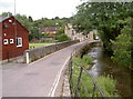
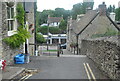
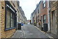
St John's Street
Looking eastwards over Goose Bridge as it crosses the Tetbury branch of the River Avon. See Image] for a look at the bowls green here.
Image: © Neil Owen
Taken: 1 Jul 2014
0.04 miles
10
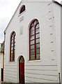
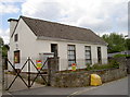
The old chapel
Located in Silver Street, this former chapel has an interesting past. Quoting from the Wiltshire Council history site:
'In 1792 a cottage was certified for Independent meetings and the Church was formed in 1796. At first services were held in a cottage near the present King's Walk but it was too small and before 1800 they acquired two cottages in Silver Street, which they converted into the Ebenezer chapel. Many of the congregation united with the Westport Presbyterians after 1812 and this movement flourished at first but did not ultimately prosper. Some were opposed to the merger and in 1841, as the friends of the Old Independent Church, they took over the Silver Street building.
This was enlarged or rebuilt in 1848 and again called the Ebenezer chapel. New seating was installed in 1885, providing accommodation for 300, and an adjacent cottage was acquired to provide two classrooms. In 1914 there was no settled minister and a union with the Westport Congregationalists was suggested but was resisted by the deacons. Instead the church prospered alone and the building was refurbished in the late 1920s. In 1952 the Independents were formally united with the Westport Congregational Church and moved to their building in St. Mary's Street. The chapel in Silver Street was used as a masonic lodge from 1958.'
See Image] for the inscribed stonework.
Image: © Neil Owen
Taken: 1 Jul 2014
0.04 miles