IMAGES TAKEN NEAR TO
Roundmead, MALMESBURY, SN16 9BP
Introduction
This page details the photographs taken nearby to Roundmead, SN16 9BP by members of the Geograph project.
The Geograph project started in 2005 with the aim of publishing, organising and preserving representative images for every square kilometre of Great Britain, Ireland and the Isle of Man.

There are currently over 7.5m images from over14,400 individuals and you can help contribute to the project by visiting https://www.geograph.org.uk
Image Map
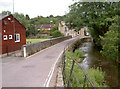
Images are licensed for reuse under creativecommons.org/licenses/by-sa/2.0
Notes
- Clicking on the map will re-center to the selected point.
- The higher the marker number, the further away the image location is from the centre of the postcode.
Image Listing (533 Images Found)
Images are licensed for reuse under creativecommons.org/licenses/by-sa/2.0
Image
Details
Distance
1
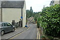
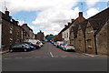
Unsuitable for HGVs, Malmesbury
Wider for its 50 metre course from High Street behind the camera, St John's Street is narrow ahead.
Image: © Jaggery
Taken: 17 Aug 2014
0.00 miles
2
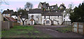
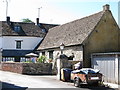
Roundmead, St. John Street, Malmesbury
The old houses in Roundmead have been gutted and stand boarded up prior to renovation. Culver House is on the hill in the background.
Image: © Vieve Forward
Taken: 20 Apr 2012
0.01 miles
3
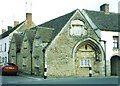
Malmesbury: St. John?s almshouses
The arch in the right-hand end as we look is reckoned to date to about 1185 and is probably a reminder of a former chapel and hospital on this site. Much more in-depth discussion will be found here: http://www.davidforward.co.uk/almshouse/almshouse.php
Image: © Chris Downer
Taken: 16 Feb 2002
0.01 miles
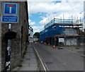
4
St John's Street, Malmesbury
Viewed from the B4042 High Street end.
Image: © Jaggery
Taken: 17 Aug 2014
0.02 miles
5
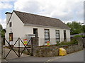
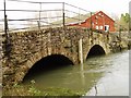
Malmesbury pumping station
Located right by the bridge, evidently containing a lot of heavy machinery and some powerful electrical installations.
Image: © Neil Owen
Taken: 1 Jul 2014
0.02 miles
6
Old Court House, St John's Street, Malmesbury
Formerly part of St John's hospital, used as court house from 1616, now part of dwelling.
Grade I listed - https://historicengland.org.uk/listing/the-list/list-entry/1269247
Image: © Steve Roberts
Taken: 27 Jun 2018
0.03 miles
7
St John's Street
Looking eastwards over Goose Bridge as it crosses the Tetbury branch of the River Avon. See Image] for a look at the bowls green here.
Image: © Neil Owen
Taken: 1 Jul 2014
0.04 miles
8
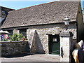
Old Court House, St John's Street, Malmesbury
Formerly part of St John's hospital, used as court house from 1616, now part of dwelling.
Grade I listed - https://historicengland.org.uk/listing/the-list/list-entry/1269247
Image: © Steve Roberts
Taken: 27 Jun 2018
0.04 miles