IMAGES TAKEN NEAR TO
St. Dennis Road, MALMESBURY, SN16 9BH
Introduction
This page details the photographs taken nearby to St. Dennis Road, SN16 9BH by members of the Geograph project.
The Geograph project started in 2005 with the aim of publishing, organising and preserving representative images for every square kilometre of Great Britain, Ireland and the Isle of Man.

There are currently over 7.5m images from over14,400 individuals and you can help contribute to the project by visiting https://www.geograph.org.uk
Image Map
Images are licensed for reuse under creativecommons.org/licenses/by-sa/2.0
Notes
- Clicking on the map will re-center to the selected point.
- The higher the marker number, the further away the image location is from the centre of the postcode.
Image Listing (618 Images Found)
Images are licensed for reuse under creativecommons.org/licenses/by-sa/2.0
Image
Details
Distance
1
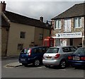
Garden Veterinary Group, Malmesbury
On the corner of Market Lane and St Dennis Lane.
Image: © Jaggery
Taken: 17 Aug 2014
0.01 miles
2
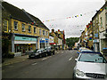
South along High Street, Malmesbury
Just beyond the zebra crossing with its belisha beacons is the junction with St Dennis Lane. The presence of bunting provides a bit of colour on a grey day.
Image: © Brian Robert Marshall
Taken: 24 Sep 2010
0.02 miles
3
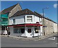
Malmesbury Rendezvous
Takeaway in High Street, on the corner of St Dennis Road (on the right).
Image: © Jaggery
Taken: 17 Aug 2014
0.02 miles
4
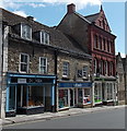
WHSmith in Malmesbury
A familiar presence in UK High Streets, WHSmith (or WHS) sells books, magazines, stationery,
eReaders, toys, games etc. This one, in the middle of the view, is in High Street Malmesbury.
Image: © Jaggery
Taken: 17 Aug 2014
0.02 miles
5
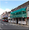
Barclays Bank under wraps in Malmesbury
Viewed across High Street in mid August 2014 when scaffolding and sheeting covered the bank branch.
Image: © Jaggery
Taken: 17 Aug 2014
0.02 miles
6
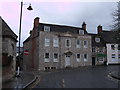
Georgian house, 32 Cross Hayes, Malmesbury
Early to mid-18th century Grade II listed Georgian house on south side of Cross Hayes. http://www.britishlistedbuildings.co.uk/en-460713-number-32-and-attached-rear-store-32-mal This photograph was taken the day scaffolding was removed after major renovation of the exterior walls.
The small house to the right of it (no. 34) is also Grade II listed. It dates to the late 18th century and was once a public house called The Brewer's Tap.http://www.britishlistedbuildings.co.uk/en-460714-34-malmesbury
Image: © Vieve Forward
Taken: 18 Apr 2012
0.02 miles
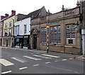
7
Mindvision Media in Malmesbury
Website development and graphic design business at 41 High Street in the former Royal Mail sorting office which closed after the opening of a larger site in Royal Wootton Bassett in June 2012.
Image: © Jaggery
Taken: 17 Aug 2014
0.02 miles
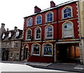
8
Lloyds Bank, Malmesbury
The High Street bank was formerly a branch of Lloyds TSB, rebranded in September 2013.
Image: © Jaggery
Taken: 17 Aug 2014
0.02 miles
9
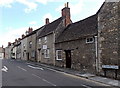
St Dennis Road, Malmesbury
Looking east from the corner of High Street.
Image: © Jaggery
Taken: 17 Aug 2014
0.02 miles
10

Henry George in Malmesbury
Estate agents at 34 St Dennis Lane.
Image: © Jaggery
Taken: 17 Aug 2014
0.02 miles