IMAGES TAKEN NEAR TO
Tetbury Hill, MALMESBURY, SN16 0RP
Introduction
This page details the photographs taken nearby to Tetbury Hill, SN16 0RP by members of the Geograph project.
The Geograph project started in 2005 with the aim of publishing, organising and preserving representative images for every square kilometre of Great Britain, Ireland and the Isle of Man.

There are currently over 7.5m images from over14,400 individuals and you can help contribute to the project by visiting https://www.geograph.org.uk
Image Map
Images are licensed for reuse under creativecommons.org/licenses/by-sa/2.0
Notes
- Clicking on the map will re-center to the selected point.
- The higher the marker number, the further away the image location is from the centre of the postcode.
Image Listing (18 Images Found)
Images are licensed for reuse under creativecommons.org/licenses/by-sa/2.0
Image
Details
Distance
1
Dyson airsock, Malmesbury
Flying on the Dyson factory in Beuttell Way, viewed across Tetbury Hill.
Image: © Jaggery
Taken: 17 Aug 2014
0.03 miles
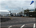
2
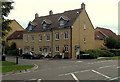
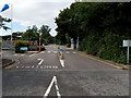
Beuttell Way, Malmesbury
Entrance from Tetbury Hill to Malmesbury Business Park.
The perimeter fence of the Dyson factory is on the right.
Image: © Jaggery
Taken: 17 Aug 2014
0.06 miles
3
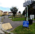
No parking for Dyson employees, Malmesbury
On the corner of Avenue de Gien and Tetbury Hill, opposite the entrance to the Dyson factory. http://www.geograph.org.uk/photo/4575092
Image: © Jaggery
Taken: 17 Aug 2014
0.06 miles
4
Corner of Tetbury Hill and Avenue de Gien, Malmesbury
Recently-built housing opposite Beuttell Way. http://www.geograph.org.uk/photo/4575100
Image: © Jaggery
Taken: 17 Aug 2014
0.06 miles
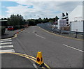
5
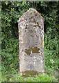
Old Milestone by Tetbury Hill, Malmesbury parish
Stone post (plate lost) by the UC road, in parish of MALMESBURY (NORTH WILTSHIRE District), Tetbury Hill; opposite new housing development, 100m South of roundabout, on embankment, on West side of road. Malmesbury First marker, erected by the Malmesbury - First District turnpike trust in the 19th century.
Inscription once read:-
(Tetbury)
(4 Miles)
(Malmsby)
(1 Mile)
Milestone Society National ID: WI_MYTB01.
Image: © M Faherty
Taken: 21 Jul 2007
0.07 miles
6
Avenue de Gien, Malmesbury
Recently-built houses viewed across Tetbury Hill. Gien in France is twinned with Malmesbury.
Image: © Jaggery
Taken: 17 Aug 2014
0.09 miles
7
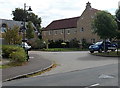
Minot Close, Malmesbury
Viewed across Tetbury Hill.
Image: © Jaggery
Taken: 17 Aug 2014
0.13 miles
8
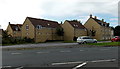
Abbey Heights, Malmesbury
Recently built Persimmon Homes houses viewed across the B4014.
Image: © Jaggery
Taken: 17 Aug 2014
0.13 miles
9
Dyson entrance, Malmesbury
From the northern end of Tetbury Hill. This is Dyson's head office and headquarters.
Image: © Jaggery
Taken: 17 Aug 2014
0.13 miles
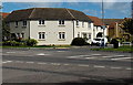
10
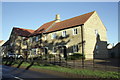
New housing on Tetbury Hill
This site was until recently occupied by The Suffolk Arms, a pub with an Ordnance Survey benchmark levelled at 91.8m above Ordnance Datum Newlyn. The houses in the picture are Nos 16 and 17.
Image: © Roger Templeman
Taken: 17 Dec 2011
0.14 miles