IMAGES TAKEN NEAR TO
Easton Grey, MALMESBURY, SN16 0RD
Introduction
This page details the photographs taken nearby to SN16 0RD by members of the Geograph project.
The Geograph project started in 2005 with the aim of publishing, organising and preserving representative images for every square kilometre of Great Britain, Ireland and the Isle of Man.

There are currently over 7.5m images from over14,400 individuals and you can help contribute to the project by visiting https://www.geograph.org.uk
Image Map
Images are licensed for reuse under creativecommons.org/licenses/by-sa/2.0
Notes
- Clicking on the map will re-center to the selected point.
- The higher the marker number, the further away the image location is from the centre of the postcode.
Image Listing (10 Images Found)
Images are licensed for reuse under creativecommons.org/licenses/by-sa/2.0
Image
Details
Distance

3
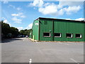
Warehouse, Whitewalls
The former POW camp at Whitewalls is now an industrial complex for small and medium-sized business, such as this warehouse/factory.
Image: © Vieve Forward
Taken: 12 Sep 2020
0.07 miles
5
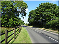
B4040, Whitewalls
At the junction with the Fosse Way Roman Road.
Image: © JThomas
Taken: 14 Jul 2019
0.11 miles
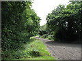
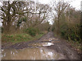
6
The Fosse Way
Now a byway. View from the B4040.
Image: © JThomas
Taken: 14 Jul 2019
0.15 miles
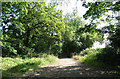
7
Fosse Way (again)
Fosse Way coming down to cross over the River Avon, just south-east of Easton Grey, West Wiltshire.
Image: © ROGER ROBERTS
Taken: 3 Jun 2009
0.17 miles
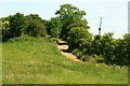
8
Fosse Way west of Malmesbury
Looking northeast from where this roman road (now a byway) crosses the B4040.
Image: © michael ely
Taken: 13 Dec 2006
0.18 miles
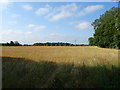
9
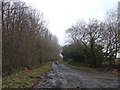
Fosse Way west of Malmesbury
Looking southwest from where this roman road (now a byway) crosses the B4040. About 400 metres further on the Fosse Way crosses the River Avon.
Image: © michael ely
Taken: 13 Dec 2006
0.18 miles
10
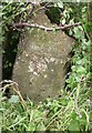
Old Milestone by the B4040, Malmesbury Road, Easton Grey Parish
Stone post (plate lost) by the B4040, in parish of EASTON GREY (NORTH WILTSHIRE District), Malmesbury Road; 700m East Easton Grey church, hidden by sloe bush on verge, on North side of road. Malmesbury iron plate, erected by the Faringdon to Acton Turville (2nd District) turnpike trust in the 19th century.
Inscription once read:- : (Bristol / 24 / Miles / Malmsby / 3 / Miles) :
Plate removed 2001 :
Grade II Listed. List Entry Number: 1356033
Milestone Society National ID: WI_MYBR03.
Image: © M Faherty
Taken: 21 Jul 2007
0.24 miles