IMAGES TAKEN NEAR TO
Sherston Road, MALMESBURY, SN16 0QX
Introduction
This page details the photographs taken nearby to Sherston Road, SN16 0QX by members of the Geograph project.
The Geograph project started in 2005 with the aim of publishing, organising and preserving representative images for every square kilometre of Great Britain, Ireland and the Isle of Man.

There are currently over 7.5m images from over14,400 individuals and you can help contribute to the project by visiting https://www.geograph.org.uk
Image Map
Images are licensed for reuse under creativecommons.org/licenses/by-sa/2.0
Notes
- Clicking on the map will re-center to the selected point.
- The higher the marker number, the further away the image location is from the centre of the postcode.
Image Listing (13 Images Found)
Images are licensed for reuse under creativecommons.org/licenses/by-sa/2.0
Image
Details
Distance
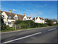
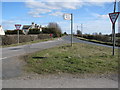
4
Twatley Cottages
On the B4040 to the west of Malmesbury. View looking southeast from the junction with the minor road to Shipton Moyne.
Image: © michael ely
Taken: 13 Dec 2006
0.07 miles
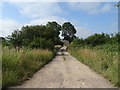
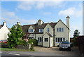
7
Fields near Boakley Farm
The cottages on the right are Twatley Cottages which are in the adjoining grid square.
Image: © Philip Halling
Taken: 22 Jun 2008
0.11 miles
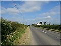
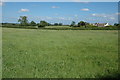
9
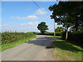
Minor road near Bob Hills
Towards Shipton Moyne.
Image: © JThomas
Taken: 14 Jul 2019
0.21 miles