IMAGES TAKEN NEAR TO
White Lion Park, MALMESBURY, SN16 0QP
Introduction
This page details the photographs taken nearby to White Lion Park, SN16 0QP by members of the Geograph project.
The Geograph project started in 2005 with the aim of publishing, organising and preserving representative images for every square kilometre of Great Britain, Ireland and the Isle of Man.

There are currently over 7.5m images from over14,400 individuals and you can help contribute to the project by visiting https://www.geograph.org.uk
Image Map
Images are licensed for reuse under creativecommons.org/licenses/by-sa/2.0
Notes
- Clicking on the map will re-center to the selected point.
- The higher the marker number, the further away the image location is from the centre of the postcode.
Image Listing (20 Images Found)
Images are licensed for reuse under creativecommons.org/licenses/by-sa/2.0
Image
Details
Distance
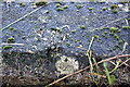
1
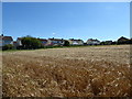
White Lion Park
The backs of houses in White Lion Park viewed from a public footpath skirting a barley field.
Image: © Vieve Forward
Taken: 6 Aug 2016
0.06 miles
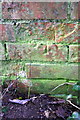
4
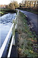
River Avon (Tetbury Branch) and Park Road
There is an OS benchmark Image on top of the wall (by the green GPS instrument)
Image: © Roger Templeman
Taken: 17 Dec 2011
0.18 miles
5
Benchmark on Park Road riverside wall
Ordnance Survey rivet benchmark described on the Bench Mark Database at http://www.bench-marks.org.uk/bm40557. The location can be seen at Image
Image: © Roger Templeman
Taken: 17 Dec 2011
0.18 miles
7
Damaged benchmark on building, Park Road
Ordnance Survey cut mark benchmark described on the Bench Mark Database at http://www.bench-marks.org.uk/bm40577
Image: © Roger Templeman
Taken: 17 Dec 2011
0.19 miles
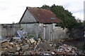
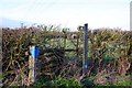
8
Small building on Park Road
I would love to know what this building is used for! It has an Ordnance Survey benchmark Image on the far end wall.
Image: © Roger Templeman
Taken: 17 Dec 2011
0.19 miles
9
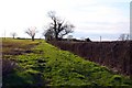
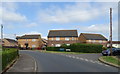
Footpath west of Malmesbury along the hedgerow
Image: © Steve Daniels
Taken: 20 Mar 2011
0.22 miles
10
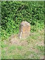
Milestone near Malmesbury
The milestone indicates that Bristol is 26 miles distance and it is only 1 mile to Malmesbury. Limestone post with cast iron plate. Image]
Image: © Maigheach-gheal
Taken: 1 Jul 2009
0.22 miles