IMAGES TAKEN NEAR TO
Exton Close, MALMESBURY, SN16 0QD
Introduction
This page details the photographs taken nearby to Exton Close, SN16 0QD by members of the Geograph project.
The Geograph project started in 2005 with the aim of publishing, organising and preserving representative images for every square kilometre of Great Britain, Ireland and the Isle of Man.

There are currently over 7.5m images from over14,400 individuals and you can help contribute to the project by visiting https://www.geograph.org.uk
Image Map
Images are licensed for reuse under creativecommons.org/licenses/by-sa/2.0
Notes
- Clicking on the map will re-center to the selected point.
- The higher the marker number, the further away the image location is from the centre of the postcode.
Image Listing (11 Images Found)
Images are licensed for reuse under creativecommons.org/licenses/by-sa/2.0
Image
Details
Distance
2
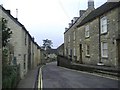
Bristol Street, Malmesbury
This is the main road west towards Sherston and eventually - Bristol.
Image: © Roger Cornfoot
Taken: 1 Jan 2007
0.13 miles
3
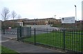
Malmesbury comprehensive school
The external appearance of these new buildings created some local controversy.
Image: © Roger Cornfoot
Taken: 1 Jan 2007
0.13 miles
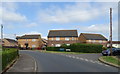
4
Corn Gastons estate
A 20th century development on the west side of this ancient town.
Image: © Roger Cornfoot
Taken: 1 Jan 2007
0.13 miles
5
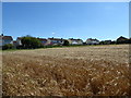
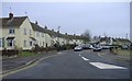
White Lion Park
The backs of houses in White Lion Park viewed from a public footpath skirting a barley field.
Image: © Vieve Forward
Taken: 6 Aug 2016
0.17 miles
6
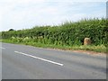
Milestone near Malmesbury
The milestone stands beside the B4040 as you enter Malmesbury.
Image: © Maigheach-gheal
Taken: 1 Jul 2009
0.24 miles
7
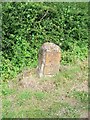
Milestone near Malmesbury
The milestone indicates that Bristol is 26 miles distance and it is only 1 mile to Malmesbury. Limestone post with cast iron plate. Image]
Image: © Maigheach-gheal
Taken: 1 Jul 2009
0.24 miles
8
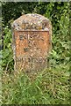
Old Milestone by the B4040, Sherston Road, Malmesbury
Metal plate attached to stone post by the B4040, in parish of BROKENBOROUGH (NORTH WILTSHIRE District), Sherston Road, western approach to Malmesbury, just before 30 mph traffic calming, on grass verge, on made up platform of concrete set into ditch in front of hedge, on North side of road. Malmesbury iron plate, erected by the Faringdon to Acton Turville (2nd District) turnpike trust in the 19th century.
Inscription reads:-
BRISTOL
26
MILES
MALMESB,Y
1
MILE
Carved benchmark and rivet on top.
Grade II listed.
List Entry Number: 1198584 https://historicengland.org.uk/listing/the-list/list-entry/1198584
Milestone Society National ID: WI_MYBR01.
Image: © A Rosevear
Taken: 20 May 2003
0.24 miles
9
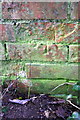
Damaged benchmark on building, Park Road
Ordnance Survey cut mark benchmark described on the Bench Mark Database at http://www.bench-marks.org.uk/bm40577
Image: © Roger Templeman
Taken: 17 Dec 2011
0.24 miles
10
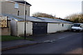
Small building on Park Road
I would love to know what this building is used for! It has an Ordnance Survey benchmark Image on the far end wall.
Image: © Roger Templeman
Taken: 17 Dec 2011
0.24 miles