IMAGES TAKEN NEAR TO
North End Gardens, MALMESBURY, SN16 0NL
Introduction
This page details the photographs taken nearby to North End Gardens, SN16 0NL by members of the Geograph project.
The Geograph project started in 2005 with the aim of publishing, organising and preserving representative images for every square kilometre of Great Britain, Ireland and the Isle of Man.

There are currently over 7.5m images from over14,400 individuals and you can help contribute to the project by visiting https://www.geograph.org.uk
Image Map
Images are licensed for reuse under creativecommons.org/licenses/by-sa/2.0
Notes
- Clicking on the map will re-center to the selected point.
- The higher the marker number, the further away the image location is from the centre of the postcode.
Image Listing (81 Images Found)
Images are licensed for reuse under creativecommons.org/licenses/by-sa/2.0
Image
Details
Distance
1
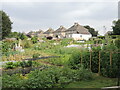
Sherston allotments
A patch for the villagers to grow more.
Image: © Neil Owen
Taken: 25 Jul 2021
0.13 miles
3
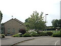
Sherston school
The village school, with a squirrel weathervane.
Image: © Neil Owen
Taken: 25 Jul 2021
0.15 miles
4
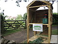
Sustainable Sherston
A stall at the corner of the allotments show the results of some hard graft.
Image: © Neil Owen
Taken: 25 Jul 2021
0.16 miles
6
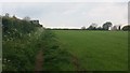
Path going up past the water tower
From the road to Stan Bridge the path going up past the water tower
Image: © Shaun Ferguson
Taken: 11 May 2019
0.17 miles
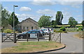
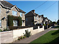
8
House at Sherston
This house dominates one of the major crossroads in the village where Green Lane , Court Street and Knockdown lane all meet the minor road to Sopworth.
Image: © Nigel Mykura
Taken: 20 Aug 2012
0.18 miles
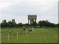
9
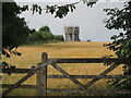
Sherston reservoir
To the west of the village is a covered reservoir, with a water tower-cum-mobile communications station.
Image: © Neil Owen
Taken: 25 Jul 2021
0.19 miles
10
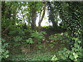
A wall around Sherston?
The ancient earthworks partly enclose a small area of land on the western edge of Sherston. It is mainly inaccessible but the embankment is clear from the road. Trees now proliferate.
Image: © Neil Owen
Taken: 25 Jul 2021
0.20 miles