IMAGES TAKEN NEAR TO
Sherston, MALMESBURY, SN16 0NG
Introduction
This page details the photographs taken nearby to SN16 0NG by members of the Geograph project.
The Geograph project started in 2005 with the aim of publishing, organising and preserving representative images for every square kilometre of Great Britain, Ireland and the Isle of Man.

There are currently over 7.5m images from over14,400 individuals and you can help contribute to the project by visiting https://www.geograph.org.uk
Image Map
Images are licensed for reuse under creativecommons.org/licenses/by-sa/2.0
Notes
- Clicking on the map will re-center to the selected point.
- The higher the marker number, the further away the image location is from the centre of the postcode.
Image Listing (160 Images Found)
Images are licensed for reuse under creativecommons.org/licenses/by-sa/2.0
Image
Details
Distance
1
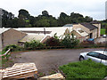
The Stretchline factory, Sherston Mill
Image: © Vieve Forward
Taken: 22 Sep 2020
0.01 miles
2
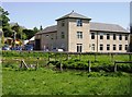
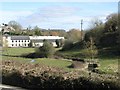
Office building near River Avon
The river in the foreground is one of the headwaters of the Bristol Avon. I completely forgot to note the owners of the office building, at the southern end of Sherston. Fortunately a correspondent has come to my rescue with this (slightly paraphrased) information: "The factory is owned by Stretchline, formerly known as Tubbs Elastic, and it is highly likely that your Eddie Grundys are held up courtesy of the elastic they produce!" Thanks Nic.
Image: © Graham Horn
Taken: 1 May 2007
0.02 miles
4
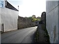
Down to the river
The High Street drops steeply to become Brook Street and cross the River Avon.
Image: © Michael Dibb
Taken: 2 Nov 2016
0.08 miles
5
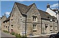
Hill Cottage, Sherston, Wiltshire 2019
Grade 2 listed
Image: © Ray Bird
Taken: 13 Jul 2019
0.09 miles
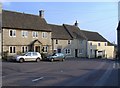
6
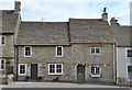
House, High Street, Sherston, Wiltshire 2015
Image: © Ray Bird
Taken: 9 Jul 2015
0.09 miles
8
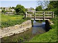
Footbridge over River Avon
This is one of the headwaters of the Bristol Avon, flowing east away from us to Malmesbury before turning south then west. The Macmillan Way long distance path crosses here, and the guidebook warns that this meadow can be flooded. It was so dry on 1st May that we could have our picnic lunch here on the bank.
Image: © Graham Horn
Taken: 1 May 2007
0.10 miles
10
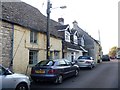
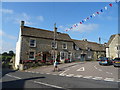
Silver Street
Another delightful street of mixed period houses.
Image: © Michael Dibb
Taken: 2 Nov 2016
0.10 miles