IMAGES TAKEN NEAR TO
High Street, MALMESBURY, SN16 0LH
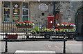
Introduction
This page details the photographs taken nearby to High Street, SN16 0LH by members of the Geograph project.
The Geograph project started in 2005 with the aim of publishing, organising and preserving representative images for every square kilometre of Great Britain, Ireland and the Isle of Man.

There are currently over 7.5m images from over14,400 individuals and you can help contribute to the project by visiting https://www.geograph.org.uk
Image Map
Images are licensed for reuse under creativecommons.org/licenses/by-sa/2.0
Notes
- Clicking on the map will re-center to the selected point.
- The higher the marker number, the further away the image location is from the centre of the postcode.
Image Listing (279 Images Found)
Images are licensed for reuse under creativecommons.org/licenses/by-sa/2.0
Image
Details
Distance
1
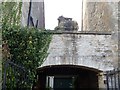
Carved sheep
Church House is linked by an arch to a late 17th century building which was once a pub, The Bell. The carved sheep over the archway dates from the 1930s when Mr Herbert Goulding opened his butcher’s shop, which continued as a butchers
until recently.
Image: © Michael Dibb
Taken: 2 Nov 2016
0.01 miles
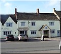
2
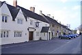
West side of the High Street
The closest building, is the former Angel Inn.
Image: © Roger Cornfoot
Taken: 7 Apr 2007
0.01 miles
3
Once the Swan Inn
Numbers 19 and 21 High Street, now two dwellings were once part of the Swan Inn along with Old Swan House which is at the rear with access via the door in the middle. Both are late 16th century, restored in the 19th century and altered in the 20th century. Listed, grade II*, with details at: https://www.historicengland.org.uk/listing/the-list/list-entry/1023244
Image: © Michael Dibb
Taken: 2 Nov 2016
0.01 miles
4
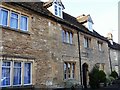
Three dwellings
Originally one house, this is now three separate dwellings accessed through the central door. Built in the 16th century and refronted in the 18th century with later alterations. Listed, grade II, with details at: https://www.historicengland.org.uk/listing/the-list/list-entry/1199795
Image: © Michael Dibb
Taken: 2 Nov 2016
0.01 miles
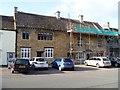
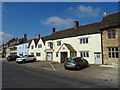
5
The Angel Hotel
The frontage to the right is late 16th century whilst the frontage to the left is dated 1648. The bus shelter detracts from a fine building. The hotel is listed, grade II, with details at: https://www.historicengland.org.uk/listing/the-list/list-entry/1283190
Image: © Michael Dibb
Taken: 2 Nov 2016
0.01 miles
7
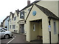
Time for some angel cake?
Sherston's ancient watering hole, and a bus stop that will tell you if you're on time. The hotel dates from the last sixteenth century and is Grade II listed. Conversion into residential use was applied for a couple of years ago but was not completed - the cafe remains open.
Image: © Neil Owen
Taken: 25 Jul 2021
0.01 miles
8
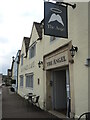
The Angel, Sherston
Built in the late sixteenth century, the Angel is a fairly large hotel for a village of its size.
Image: © Neil Owen
Taken: 25 Jul 2021
0.01 miles
9
Village Shop & P.O, High Street, Sherston, Wiltshire 2015
Image: © Ray Bird
Taken: 9 Jul 2015
0.02 miles
10

Sign for the Angel Hotel, Sherston
See Image] for context.
Image: © JThomas
Taken: 14 Jul 2019
0.02 miles