IMAGES TAKEN NEAR TO
Corston, MALMESBURY, SN16 0HW
Introduction
This page details the photographs taken nearby to SN16 0HW by members of the Geograph project.
The Geograph project started in 2005 with the aim of publishing, organising and preserving representative images for every square kilometre of Great Britain, Ireland and the Isle of Man.

There are currently over 7.5m images from over14,400 individuals and you can help contribute to the project by visiting https://www.geograph.org.uk
Image Map
Images are licensed for reuse under creativecommons.org/licenses/by-sa/2.0
Notes
- Clicking on the map will re-center to the selected point.
- The higher the marker number, the further away the image location is from the centre of the postcode.
Image Listing (9 Images Found)
Images are licensed for reuse under creativecommons.org/licenses/by-sa/2.0
Image
Details
Distance
1
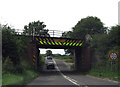
Only 14ft Headroom
The main London to South Wales railway line, built by the GWR, crosses the A429 with only 14ft to spare. Looks like it's had a few knocks and scrapes in its time.
Image: © Peter Kazmierczak
Taken: 11 Aug 2012
0.09 miles
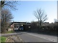
4
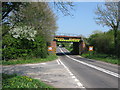
Railway bridge over the A429 road to Malmesbury
Image: © Nick Smith
Taken: 19 Apr 2011
0.11 miles
5
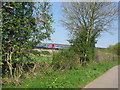
Train on the Bristol to Swindon line near Corston
Image: © Nick Smith
Taken: 19 Apr 2011
0.13 miles
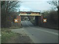
6
Rail bridge near Kingsway Barn
A view looking northeast towards the bridge carrying the railway over the A429. The roof of Kingsway Barn can be seen behind the embankment at right.
Image: © Phil Williams
Taken: 10 Apr 2006
0.14 miles
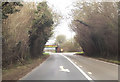
8
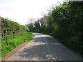
Section of lane between two bends near the A429
Image: © Nick Smith
Taken: 19 Apr 2011
0.23 miles
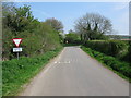
9
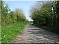
View along lane from Hullavington towards the A429
Image: © Nick Smith
Taken: 19 Apr 2011
0.25 miles