IMAGES TAKEN NEAR TO
Knockdown Road, MALMESBURY, SN16 0FP
Introduction
This page details the photographs taken nearby to Knockdown Road, SN16 0FP by members of the Geograph project.
The Geograph project started in 2005 with the aim of publishing, organising and preserving representative images for every square kilometre of Great Britain, Ireland and the Isle of Man.

There are currently over 7.5m images from over14,400 individuals and you can help contribute to the project by visiting https://www.geograph.org.uk
Image Map
Images are licensed for reuse under creativecommons.org/licenses/by-sa/2.0
Notes
- Clicking on the map will re-center to the selected point.
- The higher the marker number, the further away the image location is from the centre of the postcode.
Image Listing (4 Images Found)
Images are licensed for reuse under creativecommons.org/licenses/by-sa/2.0
Image
Details
Distance
1
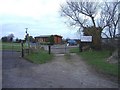
Boarding kennels and cattery
Situated to the north of Sherston.
Image: © Roger Cornfoot
Taken: 1 Feb 2007
0.02 miles
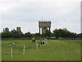
2
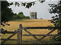
Sherston reservoir
To the west of the village is a covered reservoir, with a water tower-cum-mobile communications station.
Image: © Neil Owen
Taken: 25 Jul 2021
0.18 miles
4
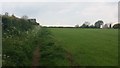
Path going up past the water tower
From the road to Stan Bridge the path going up past the water tower
Image: © Shaun Ferguson
Taken: 11 May 2019
0.23 miles