IMAGES TAKEN NEAR TO
Southside Close, MALMESBURY, SN16 0FL
Introduction
This page details the photographs taken nearby to Southside Close, SN16 0FL by members of the Geograph project.
The Geograph project started in 2005 with the aim of publishing, organising and preserving representative images for every square kilometre of Great Britain, Ireland and the Isle of Man.

There are currently over 7.5m images from over14,400 individuals and you can help contribute to the project by visiting https://www.geograph.org.uk
Image Map
Images are licensed for reuse under creativecommons.org/licenses/by-sa/2.0
Notes
- Clicking on the map will re-center to the selected point.
- The higher the marker number, the further away the image location is from the centre of the postcode.
Image Listing (41 Images Found)
Images are licensed for reuse under creativecommons.org/licenses/by-sa/2.0
Image
Details
Distance
1
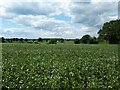
Looking across a bean field towards Corston
Image: © Vieve Forward
Taken: 2 Jun 2022
0.01 miles
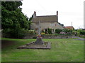
2
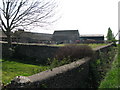
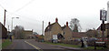
Farm buildings next to the A429, Corston
Image: © Nick Smith
Taken: 19 Apr 2011
0.03 miles
3
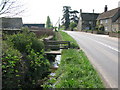
Roadside stream beside the A429 at Corston
Image: © Nick Smith
Taken: 19 Apr 2011
0.04 miles
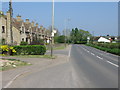
4
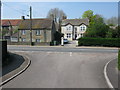
Junction of Radnor Park cul de sac with the A429
Image: © Nick Smith
Taken: 19 Apr 2011
0.08 miles
5
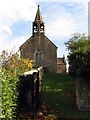
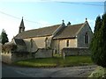
Village church in Corston
The village church, visible from the road through the village, is on the crest of the small hill and built out of Cotswold Stone.
Image: © Pam Brophy
Taken: 22 Oct 2005
0.10 miles

10
Radnor Arms Corston
From southbound A429
Image: © John Firth
Taken: 11 Apr 2013
0.14 miles