IMAGES TAKEN NEAR TO
Rodbourne, MALMESBURY, SN16 0EU
Introduction
This page details the photographs taken nearby to SN16 0EU by members of the Geograph project.
The Geograph project started in 2005 with the aim of publishing, organising and preserving representative images for every square kilometre of Great Britain, Ireland and the Isle of Man.

There are currently over 7.5m images from over14,400 individuals and you can help contribute to the project by visiting https://www.geograph.org.uk
Image Map
Images are licensed for reuse under creativecommons.org/licenses/by-sa/2.0
Notes
- Clicking on the map will re-center to the selected point.
- The higher the marker number, the further away the image location is from the centre of the postcode.
Image Listing (46 Images Found)
Images are licensed for reuse under creativecommons.org/licenses/by-sa/2.0
Image
Details
Distance
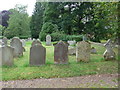
5
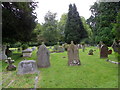
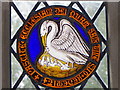
Churchyard, The Church of the Holy Rood
Image: © Maigheach-gheal
Taken: 12 Aug 2011
0.09 miles
6
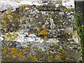
Bench Mark, The Church of the Holy Rood
Image: © Maigheach-gheal
Taken: 12 Aug 2011
0.09 miles
7
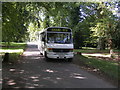
91B bus to Malmesbury (despite what it may say on the Blind)
AD Rains Bus 91B pauses in Rodbourne en route to Malmesbury in the first few weeks of the extension of the service. Despite what the blind may say, this was a normal bus service.
Image: © Michael Meilton
Taken: 9 Sep 2009
0.09 miles
10
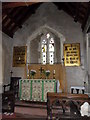
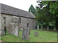
Interior, The Church of the Holy Rood
Image: © Maigheach-gheal
Taken: 12 Aug 2011
0.10 miles