IMAGES TAKEN NEAR TO
Grange Lane, MALMESBURY, SN16 0EP
Introduction
This page details the photographs taken nearby to Grange Lane, SN16 0EP by members of the Geograph project.
The Geograph project started in 2005 with the aim of publishing, organising and preserving representative images for every square kilometre of Great Britain, Ireland and the Isle of Man.

There are currently over 7.5m images from over14,400 individuals and you can help contribute to the project by visiting https://www.geograph.org.uk
Image Map
Images are licensed for reuse under creativecommons.org/licenses/by-sa/2.0
Notes
- Clicking on the map will re-center to the selected point.
- The higher the marker number, the further away the image location is from the centre of the postcode.
Image Listing (5 Images Found)
Images are licensed for reuse under creativecommons.org/licenses/by-sa/2.0
Image
Details
Distance
1
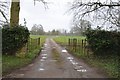
Entrance and drive to Cole Park
Entrance and drive to Cole Park off a minor road from Malmesbury to the village of Rodbourne.
Image: © Philip Halling
Taken: 17 Mar 2018
0.05 miles
2
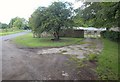
Grange Lane at Grange Farm
The entrance to the farmyard; just behnind the camera is the entrance to Cole Park.
Image: © Derek Harper
Taken: 19 Jul 2011
0.05 miles
3
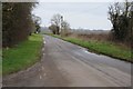
Road to Rodbourne
Country road off the A429 south of Malmesbury to the village of Rodbourne.
Image: © Philip Halling
Taken: 17 Mar 2018
0.08 miles
5
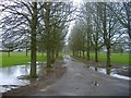
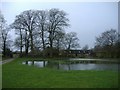
The driveway to Cole Park
Additional field drainage required?
Image: © Roger Cornfoot
Taken: 1 Jan 2007
0.09 miles