IMAGES TAKEN NEAR TO
Margery Holroyd Rise, MALMESBURY, SN16 0DX
Introduction
This page details the photographs taken nearby to Margery Holroyd Rise, SN16 0DX by members of the Geograph project.
The Geograph project started in 2005 with the aim of publishing, organising and preserving representative images for every square kilometre of Great Britain, Ireland and the Isle of Man.

There are currently over 7.5m images from over14,400 individuals and you can help contribute to the project by visiting https://www.geograph.org.uk
Image Map
Images are licensed for reuse under creativecommons.org/licenses/by-sa/2.0
Notes
- Clicking on the map will re-center to the selected point.
- The higher the marker number, the further away the image location is from the centre of the postcode.
Image Listing (124 Images Found)
Images are licensed for reuse under creativecommons.org/licenses/by-sa/2.0
Image
Details
Distance
1
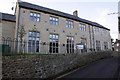
Westport Manor, Gastons Road
This new housing by Causeway Developments is on the site of the Malmesbury School Art Centre which had an Ordnance Survey benchmark levelled at 84.55m above Ordnance Datum Newlyn.
Image: © Roger Templeman
Taken: 17 Dec 2011
0.04 miles
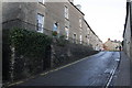
2
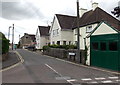
Gastons Road, Malmesbury
From the corner of Burnham Road.
Image: © Jaggery
Taken: 17 Aug 2014
0.08 miles
4
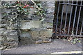
Benchmark on Bristol Street wall, below #55
Ordnance Survey cut mark benchmark described on the Bench Mark Database at http://www.bench-marks.org.uk/bm40579
Image: © Roger Templeman
Taken: 17 Dec 2011
0.11 miles
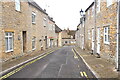
5
Bristol Street
There is an OS benchmark Image on the wall by the gated arch
Image: © Roger Templeman
Taken: 17 Dec 2011
0.11 miles
6
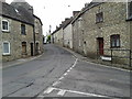
The start/end of Foxley Road in Malmesbury
Image: © Rob Purvis
Taken: 11 Jun 2013
0.11 miles
7
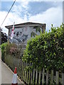
Koala mural, Pool Gastons Road
Mural by Luke Hollingworth of two koala bears on the side of 1, Pool Gastons Road, K & S Childcare's nursery.
Image: © Vieve Forward
Taken: 16 Jun 2016
0.11 miles
8
Hudson Road bench, Malmesbury
Viewed from the corner of Burnham Road.
Image: © Jaggery
Taken: 17 Aug 2014
0.12 miles
9
Burnham House electricity substation, Malmesbury
The SSE Power Distribution electricity substation is on the north side of Burnham Road, opposite Gastons Road.
SSE is short for Scottish and Southern Energy.
Image: © Jaggery
Taken: 17 Aug 2014
0.12 miles