IMAGES TAKEN NEAR TO
Park Road, MALMESBURY, SN16 0BX
Introduction
This page details the photographs taken nearby to Park Road, SN16 0BX by members of the Geograph project.
The Geograph project started in 2005 with the aim of publishing, organising and preserving representative images for every square kilometre of Great Britain, Ireland and the Isle of Man.

There are currently over 7.5m images from over14,400 individuals and you can help contribute to the project by visiting https://www.geograph.org.uk
Image Map
Images are licensed for reuse under creativecommons.org/licenses/by-sa/2.0
Notes
- Clicking on the map will re-center to the selected point.
- The higher the marker number, the further away the image location is from the centre of the postcode.
Image Listing (100 Images Found)
Images are licensed for reuse under creativecommons.org/licenses/by-sa/2.0
Image
Details
Distance
2
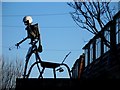
Neighbourhood Watch sculpture in Malmesbury
Welded together on the shed roof by lifelong resident David Forward.
Image: © tristan forward
Taken: 16 Dec 2006
0.06 miles
3
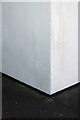
Benchmark on #1 Athelstan Road
Ordnance Survey cut mark benchmark described on the Bench Mark Database at http://www.bench-marks.org.uk/bm40578
Image: © Roger Templeman
Taken: 17 Dec 2011
0.09 miles
4
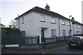
Nos 1 & 3 Athelstan Road
There is an OS benchmark Image on the facing corner of the near house.
Image: © Roger Templeman
Taken: 17 Dec 2011
0.09 miles
5
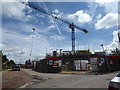
Building the new assisted living complex, Hodge Lane
Image: © Vieve Forward
Taken: 16 Jun 2016
0.10 miles
6
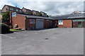
C and J Electrical in Malmesbury
Located in the Park Road Centre.
Image: © Jaggery
Taken: 17 Aug 2014
0.10 miles
7
Ryalls, Malmesbury
Building, transport and industrial supplies trade outlet located in Unit 1 Park Road Centre.
Image: © Jaggery
Taken: 17 Aug 2014
0.11 miles
8
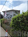
Koala mural, Pool Gastons Road
Mural by Luke Hollingworth of two koala bears on the side of 1, Pool Gastons Road, K & S Childcare's nursery.
Image: © Vieve Forward
Taken: 16 Jun 2016
0.11 miles
9
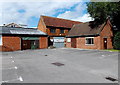
Park Road Centre, Malmesbury
A small area of businesses on the north side of Park Road. Ryalls http://www.geograph.org.uk/photo/4141292 is on the left.
Image: © Jaggery
Taken: 17 Aug 2014
0.12 miles
10
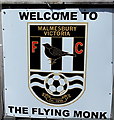
Welcome to The Flying Monk, Malmesbury
On the wall here. http://www.geograph.org.uk/photo/4127454 The Flying Monk is the home ground of Malmesbury Victoria Football Club. Their badge is shown here.
Image: © Jaggery
Taken: 17 Aug 2014
0.12 miles