IMAGES TAKEN NEAR TO
Gloucester Road, MALMESBURY, SN16 0BT
Introduction
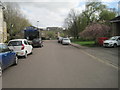
This page details the photographs taken nearby to Gloucester Road, SN16 0BT by members of the Geograph project.
The Geograph project started in 2005 with the aim of publishing, organising and preserving representative images for every square kilometre of Great Britain, Ireland and the Isle of Man.

There are currently over 7.5m images from over14,400 individuals and you can help contribute to the project by visiting https://www.geograph.org.uk
Image Map
Images are licensed for reuse under creativecommons.org/licenses/by-sa/2.0
Notes
- Clicking on the map will re-center to the selected point.
- The higher the marker number, the further away the image location is from the centre of the postcode.
Image Listing (178 Images Found)
Images are licensed for reuse under creativecommons.org/licenses/by-sa/2.0
Image
Details
Distance
1
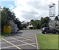
Fire station training tower, Malmesbury
At the edge of the fire station. http://www.geograph.org.uk/photo/4127360 The yellow bin is for donations to the Firefighters Charity.
Image: © Jaggery
Taken: 17 Aug 2014
0.02 miles
2
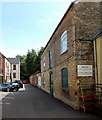
Access road to Stainsbridge Mill facilities, Malmesbury
From the east side of Gloucester Road. Notices on the wall state that this is private,
access-only, road. There is no public right of way. Trespassers will be prosecuted.
Image: © Jaggery
Taken: 17 Aug 2014
0.02 miles
3
Faded mini-roundabout in Malmesbury
Weathering and countless vehicle tyres have worn away the white paint
on the road surface at the junction of Park Road and Gloucester Road.
Image: © Jaggery
Taken: 17 Aug 2014
0.03 miles
4
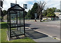
Somerfield bus shelter now opposite a Co-operative Food store in Malmesbury
The glass triangle on the side of the Gloucester Road bus shelter shows Somerfield.
The supermarket opposite the shelter now has another occupier. http://www.geograph.org.uk/photo/4127411
Image: © Jaggery
Taken: 17 Aug 2014
0.03 miles
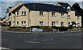
5
Athelstan Court, Malmesbury
Dwellings along Park Road, built in the first decade of the 21st century.
Image: © Jaggery
Taken: 17 Aug 2014
0.03 miles
6
Lumley Garden and Pet Supplies, Malmesbury
Located in Stainsbridge Mill, Gloucester Road.
Image: © Jaggery
Taken: 17 Aug 2014
0.03 miles
7

Malmesbury Station (remains)
View southwards to the terminus and the Abbey beyond. This was the terminus of a Great Western branch from Little Somerford (formerly from Dauntsey) on the main lines west of Swindon. Passenger traffic had ceased on 10/9/51, but goods traffic was evidently still flourishing and continued until 12/11/62. The building at the left at the end of the fence is what was the station's engine shed and is still in use as a fast-fit tyre depot.
Image: © Ben Brooksbank
Taken: 8 Apr 1958
0.04 miles
8
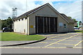
Malmesbury Fire Station
Located in Gloucester Road at the Station Yard Industrial Estate junction.
This purpose-built station was officially opened on July 9th 1969. It replaced the old fire station in the building now housing the museum in the Town Hall. The station wall shows Wiltshire Fire Brigade, an earlier name for Wiltshire Fire & Rescue Service.
Image: © Jaggery
Taken: 17 Aug 2014
0.04 miles
9
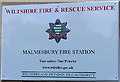
Malmesbury Fire Station nameplate
On the wall on the right here. http://www.geograph.org.uk/photo/4127360
Image: © Jaggery
Taken: 17 Aug 2014
0.04 miles
10
Malmesbury railway station (site), Wiltshire
Opened in 1871 as the terminus of a branch line from Dauntsey (later Little Somerford) on the main lines west of Swindon, this station closed to passengers in 1951 and completely in 1962. The site has since been redeveloped.
View south along the old trackbed. The single platform was to the right, on which was a single storey station building. The old engine shed on the left is the only surviving railway building. See Image for a similar view in 1958. The former engine shed and Malmesbury Abbey are reference points.
Image: © Nigel Thompson
Taken: 31 Mar 2017
0.04 miles