IMAGES TAKEN NEAR TO
Burnham Road, MALMESBURY, SN16 0BQ
Introduction
This page details the photographs taken nearby to Burnham Road, SN16 0BQ by members of the Geograph project.
The Geograph project started in 2005 with the aim of publishing, organising and preserving representative images for every square kilometre of Great Britain, Ireland and the Isle of Man.

There are currently over 7.5m images from over14,400 individuals and you can help contribute to the project by visiting https://www.geograph.org.uk
Image Map
Images are licensed for reuse under creativecommons.org/licenses/by-sa/2.0
Notes
- Clicking on the map will re-center to the selected point.
- The higher the marker number, the further away the image location is from the centre of the postcode.
Image Listing (207 Images Found)
Images are licensed for reuse under creativecommons.org/licenses/by-sa/2.0
Image
Details
Distance
1
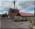
Wires over Burnham Road, Malmesbury
Looking towards Matthews Independent Funeral Directors premises at 7 Burnham Road.
Image: © Jaggery
Taken: 17 Aug 2014
0.02 miles
2
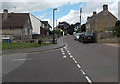
Junction of Burnham Road and Hudson Road, Malmesbury
Hudson Road on the left is a cul-de-sac on the south side of Burnham Road.
Image: © Jaggery
Taken: 17 Aug 2014
0.02 miles
3
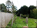
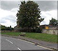
Burial ground on the north side of Burnham Road, Malmesbury
One reference states that this long, narrow area was a Baptist burial ground.
Image: © Jaggery
Taken: 17 Aug 2014
0.02 miles
4
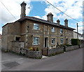
Row of three houses, Burnham Road, Malmesbury
The two upper floor blind windows could be relics of measures taken by former householders to reduce the liability under the Window Tax, introduced in 1696 in the reign of King William III, repealed in 1851.
Image: © Jaggery
Taken: 17 Aug 2014
0.03 miles
5
Hudson Road bench, Malmesbury
Viewed from the corner of Burnham Road.
Image: © Jaggery
Taken: 17 Aug 2014
0.03 miles
6
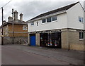
Grant Barnes & Son, Malmesbury
Saddlers viewed across Burnham Road.
Image: © Jaggery
Taken: 17 Aug 2014
0.04 miles
7
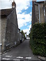
Bartons Close, Malmesbury
Cul-de-sac on the west side of West Street.
Image: © Jaggery
Taken: 17 Aug 2014
0.04 miles
8
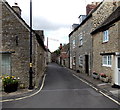
Foundry Road, Malmesbury
Looking north from Horsefair.
Image: © Jaggery
Taken: 17 Aug 2014
0.05 miles
9
Burnham House electricity substation, Malmesbury
The SSE Power Distribution electricity substation is on the north side of Burnham Road, opposite Gastons Road.
SSE is short for Scottish and Southern Energy.
Image: © Jaggery
Taken: 17 Aug 2014
0.05 miles
10
Tiny street name sign, Burnham Road, Malmesbury
The rusty, very small sign is near the right end of the wooden fence. No doubt its size was adequate when it was installed, probably when the fastest-moving people passing the sign were brisk walkers and horse & cart drivers, with an occasional bigwig galloping by on horseback.
Image: © Jaggery
Taken: 17 Aug 2014
0.05 miles