IMAGES TAKEN NEAR TO
Foxley Road, MALMESBURY, SN16 0BA
Introduction
This page details the photographs taken nearby to Foxley Road, SN16 0BA by members of the Geograph project.
The Geograph project started in 2005 with the aim of publishing, organising and preserving representative images for every square kilometre of Great Britain, Ireland and the Isle of Man.

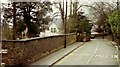
There are currently over 7.5m images from over14,400 individuals and you can help contribute to the project by visiting https://www.geograph.org.uk
Image Map
Images are licensed for reuse under creativecommons.org/licenses/by-sa/2.0
Notes
- Clicking on the map will re-center to the selected point.
- The higher the marker number, the further away the image location is from the centre of the postcode.
Image Listing (194 Images Found)
Images are licensed for reuse under creativecommons.org/licenses/by-sa/2.0
Image
Details
Distance
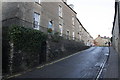
1
Bristol Street, Malmesbury.
The building on the left was the New West Hill Nursing Home when I visited in 1993.
Image: © Roger A Smith
Taken: Unknown
0.02 miles
2
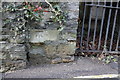
Benchmark on Bristol Street wall, below #55
Ordnance Survey cut mark benchmark described on the Bench Mark Database at http://www.bench-marks.org.uk/bm40579
Image: © Roger Templeman
Taken: 17 Dec 2011
0.03 miles
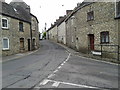
3
Bristol Street
There is an OS benchmark Image on the wall by the gated arch
Image: © Roger Templeman
Taken: 17 Dec 2011
0.03 miles
4
The start/end of Foxley Road in Malmesbury
Image: © Rob Purvis
Taken: 11 Jun 2013
0.03 miles
5
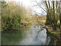
The River Avon in Malmesbury
The Sherston branch of the River Avon looking downstream from Turtle bridge.
Image: © Dr Duncan Pepper
Taken: 12 Jan 2012
0.04 miles
6
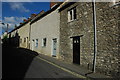
Bristol Street, Malmesbury
Unusual cottages without upstairs windows on Bristol Street in Malmesbury.
Image: © Philip Halling
Taken: 22 Jun 2008
0.04 miles
7
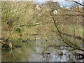
Mallard ducks enjoying an early spring day in Malmesbury
Image: © Dr Duncan Pepper
Taken: 12 Jan 2012
0.05 miles
8

Looking across the water-meadows in 1985
Towards the bulk of Malmesbury Abbey on the left and the spire of St Paul's church on the right. A little way ahead, there are two swans on the bank of the Sherston branch of the River Avon.
Image: © John Baker
Taken: 30 Sep 1985
0.06 miles
9
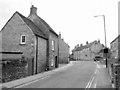
Bristol Street, Malmesbury
Looking west along the street leading out of town. Black and white somehow seemed appropriate. On the left is number 46 http://www.britishlistedbuildings.co.uk/en-460694-46-malmesbury .
Image: © Derek Harper
Taken: 19 Jul 2011
0.06 miles
10
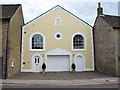
Former chapel, Malmesbury
In the blind arch in the gable is the date of this Primitive Methodist Chapel on Bristol Street: 1856. http://history.wiltshire.gov.uk/community/getchurch.php?id=423 .
Image: © Derek Harper
Taken: 19 Jul 2011
0.06 miles