IMAGES TAKEN NEAR TO
Bristol Street, MALMESBURY, SN16 0AY
Introduction
This page details the photographs taken nearby to Bristol Street, SN16 0AY by members of the Geograph project.
The Geograph project started in 2005 with the aim of publishing, organising and preserving representative images for every square kilometre of Great Britain, Ireland and the Isle of Man.

There are currently over 7.5m images from over14,400 individuals and you can help contribute to the project by visiting https://www.geograph.org.uk
Image Map
Images are licensed for reuse under creativecommons.org/licenses/by-sa/2.0
Notes
- Clicking on the map will re-center to the selected point.
- The higher the marker number, the further away the image location is from the centre of the postcode.
Image Listing (483 Images Found)
Images are licensed for reuse under creativecommons.org/licenses/by-sa/2.0
Image
Details
Distance
1
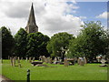
Gravestones in Malmesbury Abbey grounds
Image: © andrew auger
Taken: 15 Jun 2010
0.01 miles
6
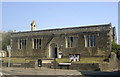
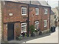
St Mary's Church Hall, Malmesbury, Wiltshire 2013
Image: © Ray Bird
Taken: 5 Jul 2013
0.03 miles
7
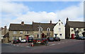
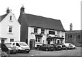
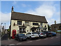
The Three Cups, Malmesbury
Pub at 90 Triangle, on the corner of St Mary's Street.
Image: © Jaggery
Taken: 17 Aug 2014
0.03 miles
8
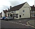
The Three Cups, Malmesbury
On The Triangle.
Image: © JThomas
Taken: 14 Jul 2019
0.03 miles
9
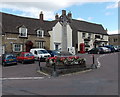
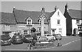
Malmesbury War Memorial
Situated in the middle of The Triangle, the Celtic cross War Memorial was dedicated in March 1921.
Image: © Jaggery
Taken: 17 Aug 2014
0.03 miles