IMAGES TAKEN NEAR TO
Katifer Lane, MALMESBURY, SN16 0AU
Introduction
This page details the photographs taken nearby to Katifer Lane, SN16 0AU by members of the Geograph project.
The Geograph project started in 2005 with the aim of publishing, organising and preserving representative images for every square kilometre of Great Britain, Ireland and the Isle of Man.

There are currently over 7.5m images from over14,400 individuals and you can help contribute to the project by visiting https://www.geograph.org.uk
Image Map
Images are licensed for reuse under creativecommons.org/licenses/by-sa/2.0
Notes
- Clicking on the map will re-center to the selected point.
- The higher the marker number, the further away the image location is from the centre of the postcode.
Image Listing (469 Images Found)
Images are licensed for reuse under creativecommons.org/licenses/by-sa/2.0
Image
Details
Distance
1
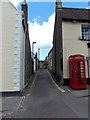
Katifer Lane, Malmesbury
Viewed across The Triangle. The red phone box is on a corner of the Three Cups pub. http://www.geograph.org.uk/photo/4127284
According to one source, this is the only Katifer (Lane, Street, Road, Avenue etc) in the UK.
Image: © Jaggery
Taken: 17 Aug 2014
0.01 miles
2
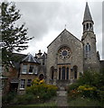
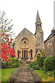
Malmesbury United Reformed Church
Set back from St Mary's Street between the Triangle and the Horsefair.
Image: © Jaggery
Taken: 17 Aug 2014
0.02 miles
3
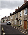
West Street south of Bartons Close, Malmesbury
Viewed from the corner of Bartons Close. http://www.geograph.org.uk/photo/4574316
Image: © Jaggery
Taken: 17 Aug 2014
0.02 miles
4
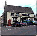
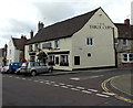
The Three Cups, Malmesbury
Pub at 90 Triangle. The red phonebox is on the corner of Katifer Lane. http://www.geograph.org.uk/photo/4574624
Image: © Jaggery
Taken: 17 Aug 2014
0.02 miles
5
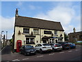
The Three Cups, Malmesbury
Pub at 90 Triangle, on the corner of St Mary's Street.
Image: © Jaggery
Taken: 17 Aug 2014
0.02 miles
6
The Three Cups, Malmesbury
On The Triangle.
Image: © JThomas
Taken: 14 Jul 2019
0.02 miles
7
United Reformed Church, Malmesbury, Wiltshire 2021
Image: © Ray Bird
Taken: 8 Oct 2021
0.02 miles
8
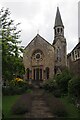
United Reformed Church in Malmesbury
This church is set back from St Mary's Street.
Image: © Jennifer Petrie
Taken: 27 Jul 2021
0.02 miles
9
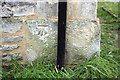
Benchmark on St Mary's Hall
Ordnance Survey cut mark benchmark described on the Bench Mark Database at http://www.bench-marks.org.uk/bm40571
Image: © Roger Templeman
Taken: 17 Dec 2011
0.03 miles
10
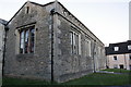
St Mary's Hall
There is an OS Benchmark Image on the base corner stone to the left of the black down pipe
Image: © Roger Templeman
Taken: 17 Dec 2011
0.03 miles