IMAGES TAKEN NEAR TO
St. Marys Lane, MALMESBURY, SN16 0AN
Introduction
This page details the photographs taken nearby to St. Marys Lane, SN16 0AN by members of the Geograph project.
The Geograph project started in 2005 with the aim of publishing, organising and preserving representative images for every square kilometre of Great Britain, Ireland and the Isle of Man.

There are currently over 7.5m images from over14,400 individuals and you can help contribute to the project by visiting https://www.geograph.org.uk
Image Map
Images are licensed for reuse under creativecommons.org/licenses/by-sa/2.0
Notes
- Clicking on the map will re-center to the selected point.
- The higher the marker number, the further away the image location is from the centre of the postcode.
Image Listing (491 Images Found)
Images are licensed for reuse under creativecommons.org/licenses/by-sa/2.0
Image
Details
Distance
1

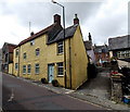
96 Gloucester Road, Malmesbury
Characterful house (and yard!) on the corner of Gloucester Road and St Mary's Lane.
Image: © Jaggery
Taken: 17 Aug 2014
0.01 miles
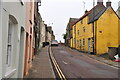
2
St Mary's Lane, Malmesbury
The eastern end of the lane viewed across Gloucester Road.
Image: © Jaggery
Taken: 17 Aug 2014
0.01 miles
3

Mey Cottage and Mayhem Cottage, Malmesbury
Viewed across Gloucester Road. The white-painted Mey Cottage at 77 Gloucester Road has various online references whereas the pink fronted Mayhem Cottage has none by that name, suggesting that its name may be a jocular invention based on the name of its neighbour.
Image: © Jaggery
Taken: 17 Aug 2014
0.02 miles
4
Gloucester Road, Malmesbury, Wiltshire 2021
Image: © Ray Bird
Taken: 8 Oct 2021
0.02 miles
5
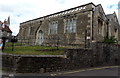
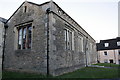
St Mary's Hall, Malmesbury
On the corner of Gloucester Road and St Mary's Street, St Mary's Hall is the home
of the 1st Malmesbury (King Athelstan) Scouts. The hall is available for hire.
Image: © Jaggery
Taken: 17 Aug 2014
0.02 miles
6
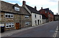
Housing variety, Gloucester Road, Malmesbury
Houses on the east side of the road, viewed looking towards the town centre.
Image: © Jaggery
Taken: 17 Aug 2014
0.02 miles
7

87-81 Gloucester Road, Malmesbury
Looking towards a bend in the road, and a gap in the houses at the NW end of Brooky Lane. http://www.geograph.org.uk/photo/4141401
Image: © Jaggery
Taken: 17 Aug 2014
0.02 miles
8

77 (L) & 75 (R) Gloucester Road, Malmesbury, Wiltshire 2021
Both Grade II listed
Image: © Ray Bird
Taken: 8 Oct 2021
0.02 miles
9
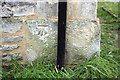
Benchmark on St Mary's Hall
Ordnance Survey cut mark benchmark described on the Bench Mark Database at http://www.bench-marks.org.uk/bm40571
Image: © Roger Templeman
Taken: 17 Dec 2011
0.02 miles
10
St Mary's Hall
There is an OS Benchmark Image on the base corner stone to the left of the black down pipe
Image: © Roger Templeman
Taken: 17 Dec 2011
0.02 miles