IMAGES TAKEN NEAR TO
Mill Lane, MALMESBURY, SN16 0AD
Introduction
This page details the photographs taken nearby to Mill Lane, SN16 0AD by members of the Geograph project.
The Geograph project started in 2005 with the aim of publishing, organising and preserving representative images for every square kilometre of Great Britain, Ireland and the Isle of Man.

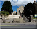
There are currently over 7.5m images from over14,400 individuals and you can help contribute to the project by visiting https://www.geograph.org.uk
Image Map
Images are licensed for reuse under creativecommons.org/licenses/by-sa/2.0
Notes
- Clicking on the map will re-center to the selected point.
- The higher the marker number, the further away the image location is from the centre of the postcode.
Image Listing (579 Images Found)
Images are licensed for reuse under creativecommons.org/licenses/by-sa/2.0
Image
Details
Distance
1
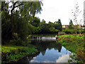
River Avon: Tetbury Branch
A view of a section of the River Avon, next to the Abbey, which eventually passes through the Abbey House and gardens just behind the photographer.
Image: © Pam Brophy
Taken: 22 Oct 2005
0.01 miles
2
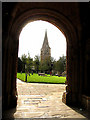
Through the Abbey Door: Malmesbury
A view of the church north west of the Abbey taken from the entrance to the Abbey.
Image: © Pam Brophy
Taken: 22 Oct 2005
0.01 miles
3
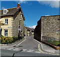
Mill Lane, Malmesbury
Viewed across the B4040 Abbey Row.
Image: © Jaggery
Taken: 17 Aug 2014
0.01 miles
4
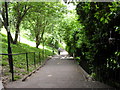
Abbey Steps, Malmesbury
Leading from the Abbey & Abbey House gardens towards the river.
Image: © andrew auger
Taken: 15 Jun 2010
0.02 miles
5
The King's Church, Malmesbury
Set back from the north side of Abbey Row. Built as a Strict Baptists chapel in 1802, with later enlargements and alterations including refurbishment in 1910. The building was Grade II listed in 1976. It continued in use as a Baptist chapel until the mid 1980s. It was bought by The King's Church from the Baptists in 1997.
Image: © Jaggery
Taken: 17 Aug 2014
0.03 miles
7
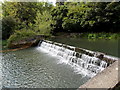
White water on the Avon, Malmesbury
The River Avon (Tetbury Branch) tumbles down a weir near the Old Abbey Mill.
Image: © Jaggery
Taken: 17 Aug 2014
0.03 miles
8
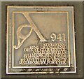
Malmesbury - King Athelstan
Plaque marking a trail around the historic town of Malmesbury.
"Athelstan the Glorious" was crowned king of England at Kingston-upon-Thames in 925 and died in 939 (Encyclopedia Britannica).
Image: © Colin Smith
Taken: 3 Jan 2018
0.03 miles
9
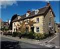
Victorian houses on the corner of Abbey Row and Mill Lane, Malmesbury
19 and 21 Abbey Row were built in the mid 19th century. Grade II listed in 1976.
Image: © Jaggery
Taken: 17 Aug 2014
0.04 miles
10
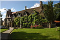
The Old Bell, Malmesbury
The Old Bell is situated immediately to the west of Malmesbury Abbey and is reputedly Englands oldest purpose built hotel. http://www.oldbellhotel.com/
Image: © Philip Halling
Taken: 22 Jun 2008
0.04 miles