IMAGES TAKEN NEAR TO
Birch Street, SWINDON, SN1 5EU
Introduction
This page details the photographs taken nearby to Birch Street, SN1 5EU by members of the Geograph project.
The Geograph project started in 2005 with the aim of publishing, organising and preserving representative images for every square kilometre of Great Britain, Ireland and the Isle of Man.

There are currently over 7.5m images from over14,400 individuals and you can help contribute to the project by visiting https://www.geograph.org.uk
Image Map
Images are licensed for reuse under creativecommons.org/licenses/by-sa/2.0
Notes
- Clicking on the map will re-center to the selected point.
- The higher the marker number, the further away the image location is from the centre of the postcode.
Image Listing (164 Images Found)
Images are licensed for reuse under creativecommons.org/licenses/by-sa/2.0
Image
Details
Distance
2
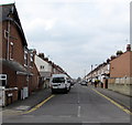
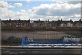
Dean Street, Swindon
Looking SW from Park Lane.
Image: © Jaggery
Taken: 15 Mar 2015
0.08 miles
4
Newburn Centre, Dean Street, Swindon
The title refers to the typical 1960s building at the left. It was built by the then British Rail Engineering Ltd ('BREL') company who were the British Rail subsidiary operating the original Great Western Railway ('GWR') railway factory nearby. The original purpose of the building was an apprentices' training school. That use became redundant some time before 1986 when the works closed for good after nearly 150 years as the engineering heart of the GWR. It is now owned by GWE Business West Workspace, part of GWE Business West Ltd and has been converted into a multi-occupied office complex. Behind this building once stood a substantial house called 'Newburn' which was once occupied by one of the key figures in the history of the GWR, G J Churchward. He was killed on the line not far from here, probably on the section of line seen here http://www.geograph.org.uk/photo/1114251
Update March 2014: the building was demolished sometime after 2009. The future of the site remains uncertain.
Image: © Brian Robert Marshall
Taken: 10 Jan 2009
0.10 miles
5

Site of the Newburn Centre, Dean Street, Swindon
The building that stood here until fairly recently has now gone Image and the future of the site remains unclear. The building was first built in 1962 as an apprentices' school and about 2400 apprentices were trained there over the next 22 years when it closed. It had a second life as a business centre until about 2010.
Image: © Brian Robert Marshall
Taken: 16 Mar 2014
0.10 miles
6
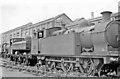
Ex-Rhymney Railway 0-6-2T dumped at Swindon Works, 1950
Amongst many other locomotives withdrawn after the War is ex-Rhymney Railway class 'A1' 0-6-2T no. 64 (built 7/14, acquired by GWR 1922, withdrawn 5/50).
Image: © Ben Brooksbank
Taken: 11 Jun 1950
0.11 miles
9
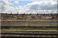
Newburn Crescent
Newburn Crescent was laid out in the 1930's as a loop connecting two older streets of terraced houses. The houses were built with metal framed bay windows, but all of these appear to have been replaced with modern upvc. Opposite in the 1950's were allotments, but these have now been built over. To the rear of the houses was greenery and only the railway line stood between them and open countryside. A glance at the OS map will reveal just how far Newburn Crescent is from the open country some 70 years later.
Image: © Gordon Hatton
Taken: 3 Jun 2010
0.11 miles
10
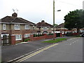
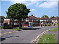
Newburn Crescent
A curious little area of between the wars housing that links the ends of older Birch Street and Dean Street. This was once land belonging to Westcott Manor Farm, itself long gone. In the 1950's the land across the road from these houses was a small area of allotment gardens, but these have now been swallowed up by more housing.
Image: © Gordon Hatton
Taken: 23 May 2017
0.11 miles