IMAGES TAKEN NEAR TO
Dean Street, SWINDON, SN1 5EP
Introduction
This page details the photographs taken nearby to Dean Street, SN1 5EP by members of the Geograph project.
The Geograph project started in 2005 with the aim of publishing, organising and preserving representative images for every square kilometre of Great Britain, Ireland and the Isle of Man.

There are currently over 7.5m images from over14,400 individuals and you can help contribute to the project by visiting https://www.geograph.org.uk
Image Map
Images are licensed for reuse under creativecommons.org/licenses/by-sa/2.0
Notes
- Clicking on the map will re-center to the selected point.
- The higher the marker number, the further away the image location is from the centre of the postcode.
Image Listing (218 Images Found)
Images are licensed for reuse under creativecommons.org/licenses/by-sa/2.0
Image
Details
Distance
1
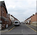
Dean Street, Swindon
Looking SW from Park Lane.
Image: © Jaggery
Taken: 15 Mar 2015
0.03 miles
3
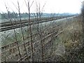
Paddington to the West Country railway, Swindon
The route of the line is as conceived by I K Brunel at the inception of the Great Western Railway in the early years of Queen Victoria's reign. Originally it was broad gauge but was converted to standard gauge before the end of the 19th century. Somewhere along this section the famous GWR Chief Mechanical Engineer, G J Churchward, met his death on 19th December 1933, 76 years before this photograph was taken. More information can be found here http://www.geograph.org.uk/photo/1113212
Image: © Brian Robert Marshall
Taken: 10 Jan 2009
0.05 miles
5
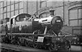
Swindon Works: '4575' 2-6-2T freshly repaired
No. 4598 (built 4/27, withdrawn 12/56). Behind is an old 4-4-0, probably doomed.
Image: © Ben Brooksbank
Taken: 25 Apr 1954
0.08 miles
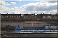
6

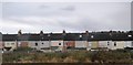
Residential development, Lynmouth Road, Swindon
These flats face Penzance Drive. Note the nod towards the history of this site in the lower left corner of the image.
Image: © Brian Robert Marshall
Taken: 24 Jan 2007
0.08 miles
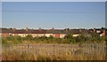
8
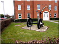
Railway wheels marking the site of Swindon Works A Shop
On the corner of Penzance Drive and Lynmouth Road in an area of modern housing built on part of the extensive former Swindon Railway works site. At its peak in the first half of the 20th century, the railway works was Swindon's main employer and one of the biggest in the country, with more than 14,500 workers.
The wheels mark a spot formerly occupied by part of the A Shop, a vast Great Western Railway workshop where locomotives were built and repaired.
Image: © Jaggery
Taken: 15 Mar 2015
0.09 miles
9
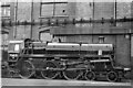
BR Standard 4MT 4-6-0 brand-new at Swindon Works
No. 75025 has still to be attached to a tender: it entered traffic 4/54 and survived until 12/65.
Image: © Ben Brooksbank
Taken: 25 Apr 1954
0.09 miles
10
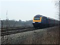
HST125 on the Paddington to the West Country railway, Swindon
'HST' stands for 'High Speed Train', '125' is the maximum operating speed in mph (miles per hour) of the train. The train is operated by First Great Western or 'FGW'. Trains like this are the workhorse of train operating companies running services over non-electrified lines like this one. It is an 'up' train meaning it is running towards or 'up' to London. It could have travelled from Bristol or South Wales. The line without the train can be seen in this image http://www.geograph.org.uk/photo/1114251
NOTE. This image has a detailed ‘shared description’ which you won’t see by viewing this image on a slideshow. To read it click on the image.
Image: © Brian Robert Marshall
Taken: 10 Jan 2009
0.09 miles