IMAGES TAKEN NEAR TO
Dean Street, SWINDON, SN1 5EN
Introduction
This page details the photographs taken nearby to Dean Street, SN1 5EN by members of the Geograph project.
The Geograph project started in 2005 with the aim of publishing, organising and preserving representative images for every square kilometre of Great Britain, Ireland and the Isle of Man.

There are currently over 7.5m images from over14,400 individuals and you can help contribute to the project by visiting https://www.geograph.org.uk
Image Map
Images are licensed for reuse under creativecommons.org/licenses/by-sa/2.0
Notes
- Clicking on the map will re-center to the selected point.
- The higher the marker number, the further away the image location is from the centre of the postcode.
Image Listing (372 Images Found)
Images are licensed for reuse under creativecommons.org/licenses/by-sa/2.0
Image
Details
Distance
1
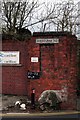
This way to the works
Rodbourne road sign on the wall. This was the road that many visitors looked for to find the way to Swindon Works. One was informed to report to the Rodbourne Road Gate house.
Image: © roger geach
Taken: 28 Oct 2008
0.04 miles
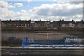
2
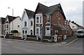
Corner of Park Lane and Dean Street, Swindon
Park Lane is on the left.
Image: © Jaggery
Taken: 15 Mar 2015
0.05 miles
3
Looking from Park Lane into Dean Street
Image: © Basher Eyre
Taken: 14 Jul 2022
0.05 miles
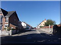
4
Dean Street, Swindon
Looking SW from Park Lane.
Image: © Jaggery
Taken: 15 Mar 2015
0.05 miles
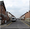
6
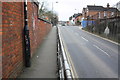
Rodbourne Road at Park Lane junction
There is an OS benchmark Image on the brick wall on the left hand side of the image about 1 foot near of the black lamppost
Image: © Roger Templeman
Taken: 15 Mar 2016
0.06 miles
7
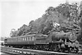
Up stopping train to Bristol passing Swindon Works
View eastward, towards Reading and London: ex-GW London - Bristol/South Wales main lines. The locomotive is Churchward 43XX 2-6-0 No. 5327 (built 9/17, modified to the heavier version as No. 8327 2/28-8/44, withdrawn 7/56). Behind the trees is the parish church built by the GWR.
Image: © Ben Brooksbank
Taken: 11 Jun 1950
0.06 miles
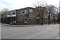
8

Territorial Army Centre, Church Place, Swindon
This relatively modern building is situated on the site of a drill hall built in 1871. The original drill hall had an area of 8000 square feet (743 square metres). The 1871 building was itself a replacement facility for an even earlier one Image built in 1861 and then converted ten years later into a hospital.
Image: © Brian Robert Marshall
Taken: 16 Mar 2014
0.07 miles
9
Military building on a Swindon corner
On the corner of Park Lane and Church Place. Names in view include
The Royal Yeomanry; 7 Rifles, Rifle Platoon; Wiltshire ACF (Army Cadet Force).
Image: © Jaggery
Taken: 15 Mar 2015
0.07 miles
10
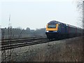
HST125 on the Paddington to the West Country railway, Swindon
'HST' stands for 'High Speed Train', '125' is the maximum operating speed in mph (miles per hour) of the train. The train is operated by First Great Western or 'FGW'. Trains like this are the workhorse of train operating companies running services over non-electrified lines like this one. It is an 'up' train meaning it is running towards or 'up' to London. It could have travelled from Bristol or South Wales. The line without the train can be seen in this image http://www.geograph.org.uk/photo/1114251
NOTE. This image has a detailed ‘shared description’ which you won’t see by viewing this image on a slideshow. To read it click on the image.
Image: © Brian Robert Marshall
Taken: 10 Jan 2009
0.07 miles