IMAGES TAKEN NEAR TO
Henry Street, SWINDON, SN1 5BX
Introduction
This page details the photographs taken nearby to Henry Street, SN1 5BX by members of the Geograph project.
The Geograph project started in 2005 with the aim of publishing, organising and preserving representative images for every square kilometre of Great Britain, Ireland and the Isle of Man.

There are currently over 7.5m images from over14,400 individuals and you can help contribute to the project by visiting https://www.geograph.org.uk
Image Map
Images are licensed for reuse under creativecommons.org/licenses/by-sa/2.0
Notes
- Clicking on the map will re-center to the selected point.
- The higher the marker number, the further away the image location is from the centre of the postcode.
Image Listing (828 Images Found)
Images are licensed for reuse under creativecommons.org/licenses/by-sa/2.0
Image
Details
Distance
1
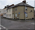
Corner of Henry Street and East Street, Swindon
Henry Street is on the left.
Image: © Jaggery
Taken: 15 Mar 2015
0.01 miles
2
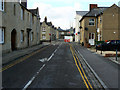
North-west along East Street, Swindon
At the left are houses built for I K Brunel's Great Western Railway company as housing for workers in the nearby factory and their families. East Street is the easternmost extent of what it known as the Railway Village. The village has been owned by the local council since the 1970s when it was bought from what was then the British Railways Board in a fairly run-down state. It was comprehensively restored and modernised and placed into the housing stock where largely it remains. It has been an urban conservation area since 1975. More about it in this pdf http://www.swindon.gov.uk/swindon_railway_village_ca_appraisal_with_map_and_mgt_plan.pdf
Image: © Brian Robert Marshall
Taken: 21 Sep 2010
0.02 miles
3
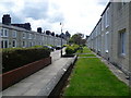
Swindon Railway Village
When the Great Western Railway opened its main railway works at Swindon in 1843, most staff came from outside the area as there was no heavy engineering tradition in North Wiltshire. The old town of Swindon could not cope with the influx so the GWR built the Railway Village. This was an estate of 300 houses for its staff. The village was finally completed in the 1860s, and although the accommodation was better than industrial houses elsewhere, many of the cottages soon became overcrowded. Most of the roads were named after places on the GWR. This is Reading Street.
Image: © Marathon
Taken: 16 Jun 2011
0.02 miles
4
Sharp looks
A building at the junction of Holbrook Way and Faringdon Road takes the curve of the layout in central Swindon. The unusual angle has allowed the architects to install windows in a similarly unusual manner.
Image: © Neil Owen
Taken: 16 Aug 2012
0.02 miles
5
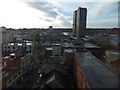
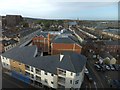
Swindon centre
View slightly east of south from Holiday Inn Express, showing shopping centre and office buildings
Image: © David Smith
Taken: 18 Oct 2012
0.02 miles
6
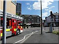
Fire engine on Fleet Street, Swindon
Image: © Ruth Sharville
Taken: 14 Jul 2022
0.02 miles
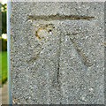
7

Cut mark, 3 East Street, Swindon
According to the 1900 Ordnance Survey map this is a bench mark at 325.3 feet above 'the assumed Mean Level of the Sea at Liverpool which is 0.650 of a Foot below the general Mean Level of the Sea.' More about it here http://www.bench-marks.org.uk/bm25596 It can be seen in context here Image
Image: © Brian Robert Marshall
Taken: 1 Nov 2010
0.02 miles
8
Cut mark, 1 East Street, Swindon
According to the 1900 Ordnance Survey map this is a bench mark at 327.3 feet above 'the assumed Mean Level of the Sea at Liverpool which is 0.650 of a Foot below the general Mean Level of the Sea.' More about it here http://www.bench-marks.org.uk/bm25595 It can be seen in context here Image
Image: © Brian Robert Marshall
Taken: 21 Sep 2010
0.03 miles
9
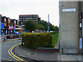
South-eastern corner of East Street, Swindon
The road leading away from the viewpoint is Faringdon Road. The cut mark seen in this image Image is just about visible at the lower left of the stone house wall just above the plinth.
Image: © Brian Robert Marshall
Taken: 21 Sep 2010
0.03 miles
10
Modern housing and Brunel's Railway Town
View slightly south of west from Holiday Inn Express, looking towards the regular street of Railway Town
Image: © David Smith
Taken: 18 Oct 2012
0.03 miles