IMAGES TAKEN NEAR TO
Upper Common, CHIPPENHAM, SN15 5PG
Introduction
This page details the photographs taken nearby to Upper Common, SN15 5PG by members of the Geograph project.
The Geograph project started in 2005 with the aim of publishing, organising and preserving representative images for every square kilometre of Great Britain, Ireland and the Isle of Man.

There are currently over 7.5m images from over14,400 individuals and you can help contribute to the project by visiting https://www.geograph.org.uk
Image Map
Images are licensed for reuse under creativecommons.org/licenses/by-sa/2.0
Notes
- Clicking on the map will re-center to the selected point.
- The higher the marker number, the further away the image location is from the centre of the postcode.
Image Listing (12 Images Found)
Images are licensed for reuse under creativecommons.org/licenses/by-sa/2.0
Image
Details
Distance
1
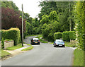
2009 : Plough Lane, leaving Kington Langley
Classified a minor road but performs a "B" road function.
Heading now to the A429, makes a useful link for anyone wishing to travel east without using the M4.
Image: © Maurice Pullin
Taken: 20 Jun 2009
0.03 miles
2
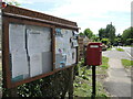
Village noticeboard at the top of Plough Lane
Some notices are kept behind glass; the rest on the right are left to the elements.
Image: © Neil Owen
Taken: 29 May 2021
0.05 miles
3
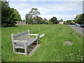
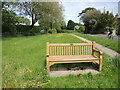
A seat on Upper Common
Plenty of open space and fresh air. The seat appears to be a replacement for an earlier version and a rubbish bin beside it has been removed.
Image: © Neil Owen
Taken: 29 May 2021
0.06 miles
4
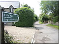
The Old Coffin Way off Parkers Lane
The bridleway links Langley Fitzurse with Kington St Michael. However, it is an old track that was once held an important role in ancient times. Some more remote parts of the landscape were sparsely populated but when an inhabitant died, it would have been only fitting and appropriate that the corpse was carried, often many miles, to a consecrated church. In some cases, a large stone would have been used on the way to rest the coffin.
This modern route may have been known as a coffin road, a burial road or lych way. Perhaps coincidentally, very close along this path was a saw mill and the old Fitzurse Manor house - would the saw mill have produced coffins?
Image: © Neil Owen
Taken: 29 May 2021
0.08 miles
5
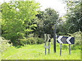
Sharp bend on Plough Lane
The road turns square at this point, but there are a couple of footpaths that branch off along the green trackways.
Image: © Neil Owen
Taken: 29 May 2021
0.09 miles
6
2009 : Upper Common, Kington Langley
"Thank you for your sponges, your scones and flapjacks
Thanks for helping us sell all the snacks.
We can’t do it without you
We say in all honesty
Where would we be
Without your cakes to go with our Teas?
So we say ‘Thank you from the Scarecrows’
it all went brilliantly!"
Liz Howe on behalf of the Scarecrow Committee
The above was copied from http://www.kingtonlangley.org/Village%20Reference.htm an excellent village website.
Image: © Maurice Pullin
Taken: 20 Jun 2009
0.15 miles
7
Commemorative seat in Langley Ridge
This wooden seat was presented by the village to mark the Royal Wedding of 1981. It has lasted a little longer.
Image: © Neil Owen
Taken: 29 May 2021
0.17 miles
8
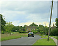
2009 : Plough Lane, Kington Langley
Just leaving Upper Common on the way to Kington St. Michael.
Image: © Maurice Pullin
Taken: 20 Jun 2009
0.22 miles
9
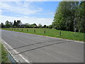
Counters on the Common
Middle Common has been chosen for some road traffic counters. Two rubber strips indicate a volume measuring set-up, three would be measure speeds.
Image: © Neil Owen
Taken: 29 May 2021
0.24 miles
10
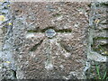
Bolt mark on the Union Chapel
A fine old 1GL boltmark can be found down the side of the old chapel, just as the building and wall meet. See https://www.bench-marks.org.uk/bm25289 for the entry in the Benchmark Database and Image] for a wider view.
Image: © Neil Owen
Taken: 29 May 2021
0.24 miles